


Anybody got any suggestions?Originally Posted by thebradybunch


Would'nt GoFree wireless allow you to do this from an Android or Apple tablet? It mirrors exactly what is on your Lowrance screen. Only drawback would be that you would have to have your units turned on while the GoFree was in range of the wireless service.
I'm not too familiar with GoFree although I do have one on my boat but I haven't bought a tablet just yet to control it so I don't know exactly what can be done.
Charlie

sorry I posted this in the other section before i found this spot. hope someone see it here. Anyways... I have a HDS-7 gen.2 and a HDI-7 units. I have several old paper maps that have many spots and notes marked. I have been wanting to transfer these over to the units. I have an extra chip that a friend sent me that has some way points from a different lake on it. So i know you can use a chip, save some way points, and then install them into a unit. However what is the best way to do this starting from no file?
Is there a way to do this on a computer? can I put my map chip in my computer and do it? I have the moble software on my iphone too but don't think I can make a waypoint there and even if I did what good would it be?
2001 Triton TR176DC, Mercury 125hp, Lowrance HDS9 gen3 & HDS7 gen2
You can add waypoints on the Navionics App and then retrieve the gps coordinates simple enough. For what you're looking for, I'm not sure if that would help you or not. In case it does, here's a video I did demonstrating it.
As far as a Navionics App for your computer that allows for waypoint management, there's currently no product offered. They used to offer NavPlanner for your PC but this product has been discontinued for a few years or better now.
There are other softwares available that'll assist.
Last edited by JDFishing; 03-02-2015 at 10:34 PM.
thank you Josh.. I will give that a try this weekend as i will be out on a lake still in winter pool too. I wish I had a touch unit now... hehehe... takes so long to input that data in a no touch unit!
2001 Triton TR176DC, Mercury 125hp, Lowrance HDS9 gen3 & HDS7 gen2
I added a new Touch 9 to my boat this weekend along with the GroFree wifi module. I am using Navionics for Sonar Charts and also experimenting with Insight Genesis. With IG I can upload my files directly to them from the depth finder over Wifi and don't have to worry about removing the SD card and taken it inside to upload my files. Does anyone know if Navionics has plans to offer upload from the depth finder or the ability to perform updates vis wifi?
^^^that would be nice^^^
Charlie
I recently purchased the Navionics + chip and have been trying to get it right. On my Unit (HDS 10 gen 2) I can't get shading or different coloration on the main chart. It just looks like a bland paper map with 1' contours (and only the good detail when zoomed in). What settings will get it closest to what the maps look like on the navionics download page/web app? I have been messing with the settings and just can't seem to find that sweet spot. I have Shading turned on, fishnchips turned on, and have messed with the contour range settings a little. Any help is greatly appreciated. Thanks! Also, i'm not getting the satellite overlay... do I need something else to see this? the lowrance is giving me all the options for it to be turned on and adjust the transparency but nothing shows up.
^^^^^^ yes I could use help here too. what is the best settings for mapping as mine is doing the same thing. Something else that I am not sure about is the best Orientation setting. I think mine is set on North up and it seems hard to drive the boat and fallow the channel to me. think It might be better as course up. what do you all do?
I would also like to know what most everyone use on the sonar settings too. Mine is working and it seems fine but if I am not using it to the level I could be then can someone please tell me?
Last edited by Roba22; 03-09-2015 at 11:47 AM.
2001 Triton TR176DC, Mercury 125hp, Lowrance HDS9 gen3 & HDS7 gen2

Satellite Overlay is only on the Hotmaps Platinum regional cards.
Navionics+ has Nautical Charts and Sonar Charts.
Nautical Charts is Navionics data.
Sonar Charts is user generated data through the Sonar Charts program.
Two separate and different maps.
Wayne Purdum
Charlottesville, Va.
Helix 12 MEGA SI+ G4N, Helix 15 MEGA SI+ GPS G4N
SOLIX 12 SI/G3, Helix 8 MEGA SI+ G4N, Ultrex 80/Advanced, MEGA360,
MEGA LIVE, LIVE TL, MEGA LIVE 2, Xplore 10
Yeah I figured that was the case. Not a big deal, but the options for satellite showed up under setting so I figured it might have had it on the chip too. My main concern is no coloring or shading, which should be part of the navionics+
I installed a new HDS9 this weekend and updated to the newest software version 4.0. I went out this weekend and ran some trails and uploaded the trails as gpx files to Navioinics for use with Sonar Charts. I then received the following email from Navionics.
Dear Customer,
Thank you for uploading your sonar logs.
We have analyzed 7 logs you uploaded on March 08, 2015.
- These logs are recorded with a Lowrance or Simrad device. At this time, Lowrance & Simrad can view SonarCharts, but they do not grant permission for logs recorded in their proprietary format to be used by Navionics for improving SonarCharts. Please contact Lowrance or Simrad with questions regarding their policy.
Your sonar logs will be saved, and in the event that it/they can be used in the future, you will be notified.
For more information about SonarCharts, Click here
Please do not reply to this mail.
Sincerely,
Navionics.
I called Navionics to ask what this meant and they explained that they have found a bug in software version 4.0. Per Navionics when the trails are being exported the depth is not being captured as part of the file. As you all know you can not build a contour map with no depth.
It would be great if some of our Lowrance reps could follow up on this with Lowrance and confirm if this is a true statement or not.

See in your post below
Kirt Hedquist
NPAA #292
Navionics Marine Specialist
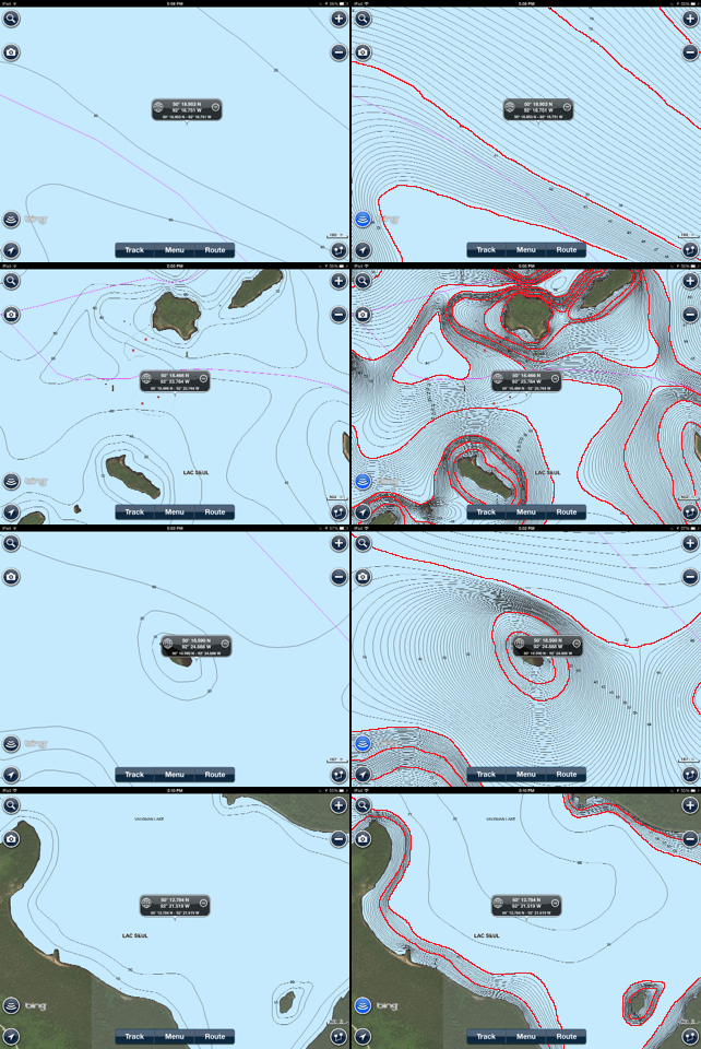
After working the Northwest Sport Show for both Navionics and Lowrance this past week, I was taken back a bit by all the interest in the new SonarChart maps that recently released from Navionics. I'm sure this doesn't apply to everyone but where I'm from, there's tons of Canadian trips taken by millions of anglers a year. Sometimes it's hard to see outside my bass fishing world I live in but for those other 98% of northern anglers check these out! All one foot contours.
Lac Seul - NauticalCharts
Lac Seul - SonarCharts
Eagle Lake - NauticalCharts
Eagle Lake - SonarCharts
Lake of the Woods (Canadian Side) - NauticalCharts
Lake of the Woods Canadian Side) - SonarCharts

I hate to burst your bubble, but the SonarCharts "1 ft Contours" are nothing more than fake lines drawn between the already inaccurate, crappy data for most of the lakes I've looked at up there in Canada. (see my side by side screenshot comparisons attached). Your own screenshots show that.
Certainly, those depths could be improved if people submit sonar recordings up there, but I have not seen any improvements for the lakes I've looked at up there. And if I upload a bunch of data, I'm donating my time and depth data to Navionics, so that they have nicer looking maps, and they sell more product because of the effort I spent collecting data for them. Plus they'll make me pay annual fees to continue to be able to upload and download updates, that I provided to them?
$200 upfront for Navionics+, plus $100 each year to continue to be able to download updates?
Am I correct on the costs?
Last edited by CamoHunter; 04-01-2015 at 08:45 PM.
Sonar Charts is a FREE service for Navionics+, Navionics Hotmaps Platinum, and Navionics Platinum+ card owners.
That chart layer is only as good as the data collected and applied. That is the whole purpose of that program.
It is not sold and is not Navionics Data, it is user data only. There is a lot of interpolation used, but that is what is changed with sonar logs. I do Sonar Charts a lot and I know where the data is accurate and where it is not. I fix the inaccurate locations with recorded sonar logs.
I fixed this area of the lake. I am the only one that is doing Sonar Charts here that I know of since it is electric-only and there is no Navionics map (Nautical Charts) for this location. The lake outline did not even exist until I submitted the first few recordings. Navionics created the zero line to apply my data.
Read Post # 668 and #669 here from yesterday:
http://www.bbcboards.net/humminbird-...arting-34.html
Wayne Purdum
Charlottesville, Va.
Helix 12 MEGA SI+ G4N, Helix 15 MEGA SI+ GPS G4N
SOLIX 12 SI/G3, Helix 8 MEGA SI+ G4N, Ultrex 80/Advanced, MEGA360,
MEGA LIVE, LIVE TL, MEGA LIVE 2, Xplore 10
I know that that data is only as good as the data that people collect and apply. But, if nobody is contributing data for lakes in Canada, then it still isn't good. My point was, that they keep advertising "1ft contours", and wowing people with a pretty looking map up there, but if you actually look at the maps JDFishing attached, they're no better than the original (until someone submits sonar logs).
I thought SonarCharts was free for the first 12months after purchase. Beyond that, I thought you needed to have a Freshest Data subscription ($100/year) to have access to SonarChart updates on your card. The Navionics website below led me to believe that, after clicking "SonarCharts" part way down the page:
The subscription is for Nautical Charts, Sonar Charts is part of the subscription. You have to have an active account to use/ participate in Sonar Charts. That is part of the account you create with the Chart Installer software.
Way down on the page is just describing the feature. You cannot purchase Sonar Charts---it's FREE.
Most waters got the preliminary contour lines when Sonar Charts was activated. It takes sonar logs to adjust the preliminary contours or add contours where there are none.
You just have to understand what Sonar Charts is and is not. If you don't know personally that any of the data is accurate anywhere, you cannot use it safely. That is what your sonar will show you.
It is NOT Navionics data.
Wayne Purdum
Charlottesville, Va.
Helix 12 MEGA SI+ G4N, Helix 15 MEGA SI+ GPS G4N
SOLIX 12 SI/G3, Helix 8 MEGA SI+ G4N, Ultrex 80/Advanced, MEGA360,
MEGA LIVE, LIVE TL, MEGA LIVE 2, Xplore 10
CamoHunter - Trust me, I completely understand your way of thinking. I actually thought it myself at first while still complaining that I want better mapping. It wasn't until I actually started to learn about lake surveying and understood that all companies that survey bodies of water do is "mow the lawn" and the rest gets guesstimated in between. Surveyors then sell the data to map makers like Navionics and all the rest. Well, how do we actually get better mapping than what we are accustomed to today? It's 100% not feasible for any company to survey a lake by every square foot and then do it a year later and then another year later. In fact, it's damn right impossible. It would take you personally hundreds and hundreds of man hours to cover a decent sized lake. The only way to ever get that kind of mapping is to crowd source. Will Navionics get better mapping from these contributions? Of course they will, that's the point. The creation of the software to do this had to be very expensive and in the end, I'll get better mapping and I'll provide better mapping as a whole.
Lowrance mapping product also believes in crowd sourcing. Humminbirds product to my knowledge does not, you also pay a pretty penny for it and still need to by your cards on top of it. Then when there are new maps whether it be SonarCharts or old fashioned NauticalCharts, you can still download your maps if your within your year subscription, if you're no longer within your year and want new maps or created your own, it'll cost $99 for another year. I believe with the competition you need to wait for the new year card with more and better mapping and then purchase it again at full value.
Could those Canada maps be better, of course they can! I really believe that they will. They're already better than what there was before and after hearing from all the guides and resort owners that were present at the Minnesota NW Sport Show that said they and their guides were going to start contributing to the program and finally have better mapping to have and sell to their guests was awesome! Eagle Lake sure is a big lake for just one guy. But 4 guides from one resort, 2 from another and 5 from another. You could see how through this program Navionics could actually put a new quality to what we all call HD mapping. At least I could.
I'm not saying nothing you said is wrong, it's your opinion but there are plenty on the other side that see it as a benefit. I already have numerous times.


 Reply With Quote


