Page 1 of 3 123 LastLast
Results 1 to 20 of 56
  1. #1
    Member
    Join Date
    Jul 2010
    Location
    Big Sandy, TX
    Posts
    647

    UNSAFE SOLIX TRACK BUGS

    When SOLIX tracks reach a large enough size, the SOLIX Display-Code does TRACK-SCRUBBING.

    The SOLIX's Display-Code attempts to lessen the processor load by removing track-points while displaying. This a Display-Code error, not Import-Code error.


    This causes two(2) problems:


    Problem#1:
    Refer to the attached JPG:
    The purple track is the true track imported via .HT file and displayed correctly until a reboot.
    The gold track is the same track imported via GPX file and Solix G1 & G2 units incorrectly display track-points.
    Solix software code incorrectly removes "apex-track-points" resulting in a cutting-the-corner path. This could be dangerous.


    Problem#2:
    Humminbird tracks can disappear when you zoom-in and the track-points are more than 200-300ft apart. This has existed since 1198/998 units. So you create the track with track-points at a distance apart to avoid "disappearing", but Solix units remove them, then the track now will disappear.
    FYI: A Lowrance HDS unit will display a track at any zoom-level even if track-points are 56miles apart, like it should.


    Humminbird has the false idea to lessen the processor-load by removing track-points with the Solix Display-Code is foolish at best.
    Solix's default track setting is to create a track-point by distance every 7ft. The default should be every 100 or 200 or 300ft.
    Default=200ft means the unit will create a track-point every 200ft OR CHANGE OF DIRECTION.


    So Humminbird current course is to create many track-points(processor-load), but then remove track-points when displaying said track to reduce processor-load.

    I hope other Solix users call Humminbird Support to ask for a bug-fix. I didn't seem to have much influence.
    888-227-7007


    This is a impact to any Solix users who wishing to create Google Earth paths and transfer to Solix units. And also if one imports existing .HT tracks.
    =================
    Other than tracks, sofar I'm enjoying Solix units.
    Last edited by LittleGazoo; 02-10-2021 at 06:39 PM.

  2. Member MichAngler's Avatar
    Join Date
    Dec 2005
    Location
    Royal Oak, MI
    Posts
    6,130
    #2
    Don’t feel bad I’ve called them lots of times and have had no success in getting them to improve the NAV system either

    And since the Solix has an issue saving tracks you won’t have to worried about it for long

    I cover so much ground that the track I’m laying down today will be gone in less than a week

    If you’re laying down a track that you need to follow closely and repeatedly I would create a route
    "The handicapped angler"

  3. Member
    Join Date
    Jul 2010
    Location
    Big Sandy, TX
    Posts
    647
    #3
    Quote Originally Posted by MichAngler View Post
    If you’re laying down a track that you need to follow closely and repeatedly I would create a route
    Routing does not work for creek's tracks due to the number of track-points. Don't need an additional 1000-5000 waypoints clutter.

  4. Member MichAngler's Avatar
    Join Date
    Dec 2005
    Location
    Royal Oak, MI
    Posts
    6,130
    #4
    Quote Originally Posted by LittleGazoo View Post
    Routing does not work for creek's tracks due to the number of track-points. Don't need an additional 1000-5000 waypoints clutter.
    Yea another issue with HB I forgot about I know other brands will create your route and does not add waypoints

    Personally I gave up on HB’s nav system last year and started using an old Garmin for my navigation

    I love HB’s imaging but they fall real short when it comes to this type of stuff

    Unfortunately many people don’t need or know what they are missing when it comes to the nav system and as long as the imaging keeps people buying the units they aren’t about to change
    "The handicapped angler"

  5. Member
    Join Date
    Apr 2011
    Location
    Mechanicsville, MD
    Posts
    1,179
    #5
    Could not agree more Humminbird tracks are the worse in the industry. My current track one day will be 5000 plus miles and change throughout the day both up and down. I have followed what the humminbird tech recommend to no avail. Reset Nav data as suggested no avail. Tracks do not work in accordance with their instructions manual. Its is the saddest navigation system on the market for sure.

    2023 Phoenix 920 Elite
    2023 Mercury Pro XS 4S

  6. Member
    Join Date
    Apr 2008
    Location
    Lakeview,AR.
    Posts
    8,058
    #6
    It is all about choices! We all have different wants and needs. We are all free to buy what we want. JMHO Bob
    Tell me where has a slow movin' once quick draw outlaw got to go

  7. Member MichAngler's Avatar
    Join Date
    Dec 2005
    Location
    Royal Oak, MI
    Posts
    6,130
    #7
    Quote Originally Posted by bobcoy View Post
    It is all about choices! We all have different wants and needs. We are all free to buy what we want. JMHO Bob
    We do “Have Choices” and we make them based on what a company says a product can and will do

    We all have the same “Want” to buy something that actually does what it’s supposed to do

    We all “Need” to be able to trust a company to do this

    We “Are Free” to buy what we want but once we’ve made that choice if it doesn’t do what it should it’s not “Free” to replace it

    Not everyone has an extra 5 to 10 grand lying around to just ignore a company’s failure and replace it with an entirely new setup

    And to mock some ones problem is not humble at all
    "The handicapped angler"

  8. Member
    Join Date
    Apr 2008
    Location
    Lakeview,AR.
    Posts
    8,058
    #8
    If WE want something to change for us individually. It might take a long time before(if ever) that happens! At some point, we cut our losses. I have made choices that turned out to be less positive than I had hoped(am on my 3rd wife). However at some point you have to go a different direction. Just complaining is not the best way to go in my opinion. If I bought everything the manufacturers told me was the Cat's...Meow I would not be a happy guy either. Bob
    Sorry to some of the ladies. One died and the current one is great! (was just to make a point!)
    Tell me where has a slow movin' once quick draw outlaw got to go

  9. Member
    Join Date
    Jul 2010
    Location
    Big Sandy, TX
    Posts
    647
    #9
    Quote Originally Posted by bobcoy View Post
    If WE want something to change for us individually. It might take a long time before(if ever) that happens! At some point, we cut our losses.
    Well unless Humminbird comes up with a workaround or fix, then SOLIX units will not support products that work on other units(Lowrance, Helix, Garmin, etc).

    Lance Vick BOATLANES not supported.
    Tom Mayne GUIDELANES not supported.
    Tommy Martin's GPSLAKEMAPS not supported.
    Personal Google Earth tracks not supported.
    Last edited by LittleGazoo; 10-26-2020 at 11:07 AM.

  10. Member Wayne P.'s Avatar
    Join Date
    Jan 2010
    Location
    Charlottesville, VA
    Posts
    30,414
    #10
    Quote Originally Posted by LittleGazoo View Post
    Well unless Humminbird comes up with a workaround or fix, then SOLIX units will not support products that work on other units(Lowrance, Helix, etc).

    Lance Vick BOATLANES not supported.
    Tommy Martin's GPSLAKEMAPS not supported.
    Personal Google Earth tracks not supported.

    So if you have a SOLIX, you can idle Fork, Sam Rayburn and Toledo Bend.
    Same Google Earth Path files converted to Humminbird Tracks:

    Helix:


    SOLIX:

    Wayne Purdum
    Charlottesville, Va.
    Helix 12 CHIRP MEGA+ SI G3N/G4N, Helix 15 CHIRP MEGA SI+ GPS G4N
    SOLIX 12 SI/G3, Helix 8 CHIRP MEGA SI+ G4N, Ultrex 80/LINK, MEGA360,
    MEGA LIVE, LIVE TL

  11. Member
    Join Date
    Jul 2010
    Location
    Big Sandy, TX
    Posts
    647
    #11
    A simple or little Google Earth path will convert to Solix. Or if you create track-points 7ft apart making the cut-corner affect small.
    I create & work with tracks of >2000 track-points. Some over 10,000 track-points So I would have to manually increase track-ooints X 3.

    Are those 1 track or 4 individual tracks?
    Solix track-point removal starts only after a track passes a certain size parameter. Humminbird has not answered if this parameter is a number of track-points or a length in miles.

    Now Wayne, if you want to test, I send you a Google Earth path to convert to GPX and HT tracks.
    Or I'll send the Humminbird .HT and .GPX tracks.
    Last edited by LittleGazoo; 09-28-2020 at 01:09 PM.

  12. Member Wayne P.'s Avatar
    Join Date
    Jan 2010
    Location
    Charlottesville, VA
    Posts
    30,414
    #12
    Quote Originally Posted by LittleGazoo View Post
    A simple or little Google Earth path will convert to Solix. Or if you create track-points 7ft apart making the cut-corner affect small.
    I create & work with tracks of >2000 track-points. Some over 10,000 track-points So I would have to manually increase track-ooints X 3.

    Are those 1 track or 4 individual tracks?
    Solix track-point removal starts only after a track passes a certain size parameter. Humminbird has not answered if this parameter is a number of track-points or a length in miles.

    Now Wayne, if you want to test, I send you a Google Earth path to convert to GPX and HT tracks.
    Or I'll send the Humminbird .HT and .GPX tracks.

    The red lines are 5 individual tracks. Merging didn't work without all the straight line connections.

    I was not allowing for any particular spacing between track points, I was drawing the actual creek channel paths as they physically are. The spacing is variable. Accuracy is the purpose of doing it. If a particular section is straight for 50', that would be the spacing for that part of it.

    Never needed to draw a track that is longer than the unit default track point number. I delete Current Track often so that is never an issue.

    No thanks for checking your data, what I do works well for me.
    Wayne Purdum
    Charlottesville, Va.
    Helix 12 CHIRP MEGA+ SI G3N/G4N, Helix 15 CHIRP MEGA SI+ GPS G4N
    SOLIX 12 SI/G3, Helix 8 CHIRP MEGA SI+ G4N, Ultrex 80/LINK, MEGA360,
    MEGA LIVE, LIVE TL

  13. Member
    Join Date
    Jul 2010
    Location
    Big Sandy, TX
    Posts
    647
    #13
    Wayne,
    We had several PM's discussing this Solix track bug prior to my opening post and recently another.

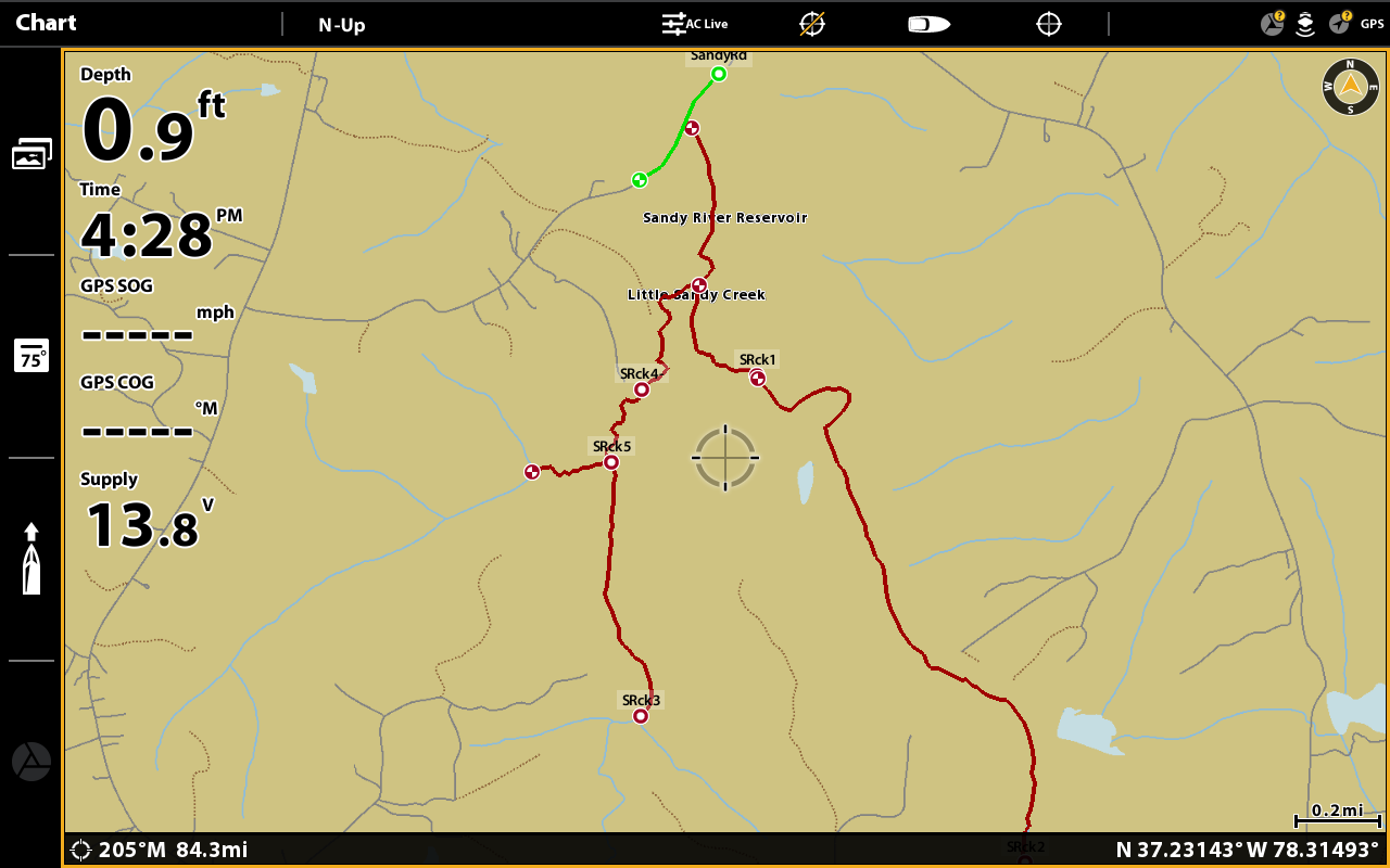
    Your building tracks for 400 acre lakes so your tracks are not being scrubbed by a Solix because they are too small. So yeah, it works for you.
    I respect you and all the help you've given to this HB forum, but please don't gaslight this thread with examples that can be build which are not relevant.

    HB has a mess with Solix tracking.
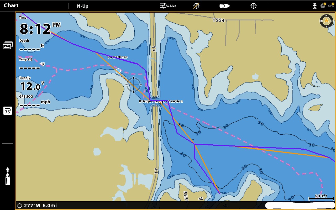
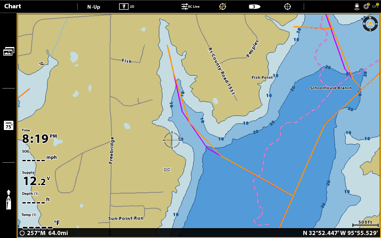
    First:
    A scrubbing bug which removes a apex-track-points which destroys track integrity. Current Track has the bug also, but because most users run Default Track Setting creating a track-point every 7 feet, then removing "apex-track-points" causing a very minimized loss of accuracy even after track-point scrubbing.
    Second:
    Management decision to scrub track-point at all. One idiocy is creating 7-foot track-point intervals by default. Set the track-point distance at 100-300 foot intervals resulting in a new track-point every 100-300ft OR CHANGE IN DIRECTION. Less processor-load creating and no need to scrub. Win-Win. QED


    HB Support first response was that the Solix Display-Code scrubbed track-points to reduce load on the hardware processor. HB's second response was the standard "not responsible for navigation use of their products". I've since requested and awaiting some technical responses as I search for a doable workaround. Still waiting for a Humminbird call-back, but really do not think it is coming.

    I like my Humminbird's. I attempted to report and resolve with HB. I suggested solutions. But I do not work for HB, but with HB's responses, I'm warning HB users that Solix tracking might not be trustworthy for safety. Sorry HB.
    Last edited by LittleGazoo; 10-01-2020 at 06:02 AM.

  14. Member
    Join Date
    Jul 2010
    Location
    Big Sandy, TX
    Posts
    647
    #14
    This Solix track error is on Solix G1, G2 and I'm certain it will exists on Solix G3 units also.
    Posting another example of how severe the Humminbird Solix tracking bug is. Purple is the correct path and gold is the track on a Solix. Notice the degree the gold track is off-course by the HB scale at 500ft.
    A large stump-field exists at the cursor location from the shown creek and point of land. Solix cut-off track path is thru the center of this stump-field.
    HB Helix and Legacy unit tracks are OK, but don't trust Solix tracks.


    Last edited by LittleGazoo; 10-07-2020 at 12:15 PM.

  15. Member
    Join Date
    Jul 2010
    Location
    Big Sandy, TX
    Posts
    647
    #15
    Did a Solix test importing tracks via .KML file. Yes, a Solix will import .KML(not KMZ).

    One, track with 60 segments will import as individual tracks with the maximum of 50. Bummer.
    Two, non-segmented track will import and display as a corrupted track. Bummer.
    SO, NO JOY...

    Large tracks can only be imported via .HT files and display as accurate. HT downside is you will have to edit all imported tracks to set track characteristics. IE Different colors. And HT tracks will display corruptly after Solix unit is rebooted.

    HB really needs to turn-off or remove Display Scrubbing from Solix software.
    Last edited by LittleGazoo; 10-24-2020 at 01:47 PM.

  16. Banned
    Join Date
    Apr 2017
    Location
    Florence Al
    Posts
    1,308
    #16
    Quote Originally Posted by bobcoy View Post
    If WE want something to change for us individually. It might take a long time before(if ever) that happens! At some point, we cut our losses. I have made choices that turned out to be less positive than I had hoped(am on my 3rd wife). However at some point you have to go a different direction. Just complaining is not the best way to go in my opinion. If I bought everything the manufacturers told me was the Cat's...Meow I would not be a happy guy either. Bob
    Sorry to some of the ladies. One died and the current one is great! (was just to make a point!)
    They are asking for something that is a safety concern for some. I don't think this is complaining.

    They have the worst nav/waypoint management system by a long shot. Every update I'm hopeful it will change but it doesn't. I have the money to run anything I want or even multiple brands BUT I network for a reason. They need to spend some time on their entire nav system.

  17. Member MichAngler's Avatar
    Join Date
    Dec 2005
    Location
    Royal Oak, MI
    Posts
    6,130
    #17
    Quote Originally Posted by pfisher View Post
    They are asking for something that is a safety concern for some. I don't think this is complaining.

    They have the worst nav/waypoint management system by a long shot. Every update I'm hopeful it will change but it doesn't. I have the money to run anything I want or even multiple brands BUT I network for a reason. They need to spend some time on their entire nav system.
    Can I get an AMEN!

    I’ve been saying the exact same thing for over ten years hoping they would upgrade this

    This is basically the same nav system they had for more than ten years just adding mapping
    Unfortunately if they want to keep people that have used other brands they will need to make major changes to this nav system

    I came from using Garmin (Best Nav system out there) and if HB would even come close to what Garmin had 20 years ago I wouldn’t own a single Garmin but I’m looking at dropping a Solix and upgrade a Garmin picking up 2 Garmin’s for nav and livescope
    "The handicapped angler"

  18. Member
    Join Date
    Jul 2010
    Location
    Big Sandy, TX
    Posts
    647
    #18
    Quote Originally Posted by MichAngler View Post
    . . .This is basically the same nav system they had for more than ten years just adding mapping
    Unfortunately if they want to keep people that have used other brands they will need to make major changes to this nav system
    I came from using Garmin (Best Nav system out there). . .
    The only issue I have will Garmin is that Garmin units do not support any track-segmentation. Track-segmentation is a major feature of the industry-standard GPX format. Humminbird and Lowrance both support track-segmentation. Exception is Humminbird Solix units corrupt any and all large tracks whether segmented or non-segmented.

    I've not a lot of experience with Garmin units(but I do have a GPSMAP 1222 for Livescope), but I'll lean toward Lowrance:
    • Track-segmentation supported.
    • Track-points can be separated by miles and display track at any zoom-level.
    • USR export/import maintains persistence with waypoint & track characteristics(icon, color, etc).
    • USR & GPX files allow multiple lakes on a SD-card versus Humminbird MATRIX one folder, one lake.
    • Navigation screens have fast response.
    • MAJOR: Lowrance supports SASPlanet/Insight Map Creator building of high-definition Historical Image Maps from Google Earth and other sources. I've seen low-water historical maps which one can see the roots of stumps, etc.
      "Fishton" has taken HD to extreme levels.

    Garmin needs to support track-segmentation.

  19. Member
    Join Date
    Apr 2008
    Location
    Lakeview,AR.
    Posts
    8,058
    #19
    Quote Originally Posted by pfisher View Post
    They are asking for something that is a safety concern for some. I don't think this is complaining.

    They have the worst nav/waypoint management system by a long shot. Every update I'm hopeful it will change but it doesn't. I have the money to run anything I want or even multiple brands BUT I network for a reason. They need to spend some time on their entire nav system.
    My point was, after some point we need to do something different(Brand) or decide to keep what we have for whatever reason and work around the difficulty. Luckily I don't need a sophisticated navigation system. Although I complained to HB about the Solix navigation for a time, I decided to change how I do things rather than be hacked off all the time or spend the money to go another direction. Life is too short to aggravate ones self more than necessary. JMO
    Tell me where has a slow movin' once quick draw outlaw got to go

  20. Member MichAngler's Avatar
    Join Date
    Dec 2005
    Location
    Royal Oak, MI
    Posts
    6,130
    #20
    Quote Originally Posted by LittleGazoo View Post
    The only issue I have will Garmin is that Garmin units do not support any track-segmentation. Track-segmentation is a major feature of the industry-standard GPX format. Humminbird and Lowrance both support track-segmentation. Exception is Humminbird Solix units corrupt any and all large tracks whether segmented or non-segmented.

    I've not a lot of experience with Garmin units(but I do have a GPSMAP 1222 for Livescope), but I'll lean toward Lowrance:
    • Track-segmentation supported.
    • Track-points can be separated by miles and display track at any zoom-level.
    • USR export/import maintains persistence with waypoint & track characteristics(icon, color, etc).
    • USR & GPX files allow multiple lakes on a SD-card versus Humminbird MATRIX one folder, one lake.
    • Navigation screens have fast response.
    • MAJOR: Lowrance supports SASPlanet/Insight Map Creator building of high-definition Historical Image Maps from Google Earth and other sources. I've seen low-water historical maps which one can see the roots of stumps, etc.
      "Fishton" has taken HD to extreme levels.

    Garmin needs to support track-segmentation.
    I can’t speak for the newest models but I’ve been using Garmin’s for 20+ years and you can cut a track into as many segments as you want and save each segment as a different track
    I do it all the time when I want to mark a large rock pile I will use the trolling motor and run the outside or the rock pile and save that segment so when I came back I can see exactly how the rock pile looks

    If I do a drift that works several times I will save that segment of the track as a separate track

    They show at all zoom levels and you can change the color

    And unlike HB a track doesn’t fill the system with tons of waypoints
    "The handicapped angler"

Page 1 of 3 123 LastLast