AutoChart Pro PC Program the SI Mosaics are on the PC. Only on the ONIX & ION are the SI Mosaics an overlay and it doesn't matter the map data in the unit.Originally Posted by jimmybass2


AutoChart Pro PC Program the SI Mosaics are on the PC. Only on the ONIX & ION are the SI Mosaics an overlay and it doesn't matter the map data in the unit.
--
http://www.dougvahrenberg.com/
BASS Central Open- Competitive Bass Angler and Humminbird Guru
Visit my website to learn about my sponsor's products, fishing tips and techniques.
Learn More About Humminbird Side Imaging Visit: http://groups.yahoo.com/group/sideimaginggroup/

Doug, so I can just import the older recordings from any sd card to the pc and make a map?

Doug, so are you saying I cannot make an SI Mosaic to put on my 1198/998? Only on the PC?
Jimmy Young
2021 Nitro Z19
Mercury 200 ProXS
Atlas 10" Hydraulic Jackplate
Humminbird HELIX 12 CHIRP MEGA SI+ GPS G4N
Humminbird HELIX 12 CHIRP MEGA DI+ GPS G4N
Humminbird SOLIX 12 CHIRP MEGA SI+ G3 (at bow)
Humminbird SOLIX 10 CHIRP MEGA SI+ G3 CHO (at bow)
Humminbird MEGA Live1 with Target Lock
Humminbird MEGA 360
Humminbird AS ETH 5PGL 5-Port Ethernet Switch (2 conneted together)
Minn Kota Ultrex i-Pilot Link
Dual Power Pole Blades
Import from the SD Card into Auto Chart PC Program on your computer
--
http://www.dougvahrenberg.com/
BASS Central Open- Competitive Bass Angler and Humminbird Guru
Visit my website to learn about my sponsor's products, fishing tips and techniques.
Learn More About Humminbird Side Imaging Visit: http://groups.yahoo.com/group/sideimaginggroup/
My understanding the SI Mosiacs for the CORE Products 800. 900 and 1100 Series are not available as overlay only viewable on the computer
--
http://www.dougvahrenberg.com/
BASS Central Open- Competitive Bass Angler and Humminbird Guru
Visit my website to learn about my sponsor's products, fishing tips and techniques.
Learn More About Humminbird Side Imaging Visit: http://groups.yahoo.com/group/sideimaginggroup/
Thanks Doug !
I have an ONIX CP +SM3000 and CHIRP transducer) I use navionics and JEPPESEN CMAP4D (best for salt water for tide and curent) autochart live work well for navionics but I don't have menu with cmap4D for autochart live, I forget to do something?
(Sorry for my english I'm french!)
OOPS! I was Wrong! Auto Chart Pro PC will allow SI Mosaics to be displayed on the unit. Here is an Image J.Hammond shared on the Facebook Side Imaging Group that shows the Mosaics and Contours Created with Auto Chart Pro PC Program.
--
http://www.dougvahrenberg.com/
BASS Central Open- Competitive Bass Angler and Humminbird Guru
Visit my website to learn about my sponsor's products, fishing tips and techniques.
Learn More About Humminbird Side Imaging Visit: http://groups.yahoo.com/group/sideimaginggroup/
This shows the benefits of Auto Chart PC Program and Immediate Custom Mapping. Here is some images a user shared on the Facebook Side Imaging Group
Before
Here is Auto Chart Mapping created from converting Sonar Recordings Instantly in the PC
And here is 3D View of the Auto Chart PC Data on the Computer.
Look at the additional details and how easy it is create mapping from sonar recordings. Scan, Convert and Export and getting mapping instantly on your own PC.
--
http://www.dougvahrenberg.com/
BASS Central Open- Competitive Bass Angler and Humminbird Guru
Visit my website to learn about my sponsor's products, fishing tips and techniques.
Learn More About Humminbird Side Imaging Visit: http://groups.yahoo.com/group/sideimaginggroup/
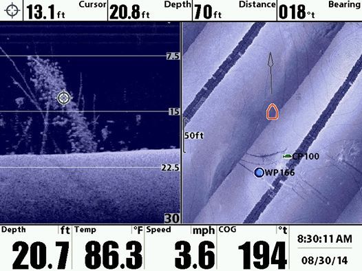
Here a wreck (150m long) in french water done in few minutes, easy and great help for fishing! Now I'm not blind on the water!
I put only few lines, need to keep screen clear!
I waiting for my sd zero line card for more surface, but french sellers receive only US card and not europe one!!
http://img15.hostingpics.net/pics/20...0902140305.jpg
Got to play with Auto Chart PC Program on a Conservation Lake that offered no mapping and amazing what Auto Chart PC Program can do. Hi-Def Mapping that I invested my time to create and I can enjoy and control who else I want to to enjoy. And in just a Few Button Clicks it was ready to use.
My Track Lines
Map Data Convert with one Click
Exported as LakeMaster Style Mapping
Here some other views from Auto Charts lots of cool tools to work with Mapping
And the PRO Version of Auto Chart allows you to add SI Mosaics and even play them back...I'm going to be creating lots of waypoints from this part of the program.
And Bottom Hardness Map too

--
http://www.dougvahrenberg.com/
BASS Central Open- Competitive Bass Angler and Humminbird Guru
Visit my website to learn about my sponsor's products, fishing tips and techniques.
Learn More About Humminbird Side Imaging Visit: http://groups.yahoo.com/group/sideimaginggroup/
Here's Zero Line Lake Examples for Canadian Anglers...lots of water available to scan it looks like.
Here's some zoomed in shots
Zero Lines are used for AutoChart PC Mapping data to be exported too.
--
http://www.dougvahrenberg.com/
BASS Central Open- Competitive Bass Angler and Humminbird Guru
Visit my website to learn about my sponsor's products, fishing tips and techniques.
Learn More About Humminbird Side Imaging Visit: http://groups.yahoo.com/group/sideimaginggroup/

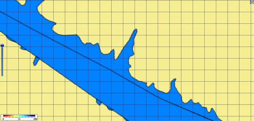
What are my options if the zero line provided on the Autocharts card for the body of water I'm interested in resemble the doodlings of a third-grader? I can provide a pic of what I mean. Extraneous zero lines in the middle of a lake do not make for a useful map. I do have a kml file for this body of water that I made for a different purpose. I've tried importing that into Autocharts with limited success, as the depth map was already calculated using the zero lines provided on the Autocharts card.
Pics: first shows a zero line in the middle of a cove, and certain coves cut off by a zero line. When mapped, the software treats one side of the zero line as shore so my map shows land in the middle of the left cove here.
Same problem below. When mapped, this zero line running down the middle of the lake creates a land mass where the actual depth is 25-35 fow.
Last edited by mudkart; 11-02-2014 at 07:42 PM.
You can build custom ZeroLines. This Tips from Humminbird may help with the information to get your mapping needs created: http://www.humminbird.com/Category/S...AQ/ZL_NotInAC/
--
http://www.dougvahrenberg.com/
BASS Central Open- Competitive Bass Angler and Humminbird Guru
Visit my website to learn about my sponsor's products, fishing tips and techniques.
Learn More About Humminbird Side Imaging Visit: http://groups.yahoo.com/group/sideimaginggroup/
Thanks. But, I've tried that already, as stated above. The situation you're talking about is when there are no zero lines on the Autochart card for the lake of interest. That is not the case for me.
My trouble is the zero lines provided by Humminbird are very bad, so much so that any maps created using them are laughable. I'd like to be rid of the zero lines provided by Autocharts altogether, then use my own.
Look at Item 3 & Item 4 in that FAQ.
Item 3 is Custom Zero Line
Item 4 is Creating Custom Zero Lines
There are 4 Topics of Discussions. If that that doesn't help call Humminbird Customer Service 800-633-1468
--
http://www.dougvahrenberg.com/
BASS Central Open- Competitive Bass Angler and Humminbird Guru
Visit my website to learn about my sponsor's products, fishing tips and techniques.
Learn More About Humminbird Side Imaging Visit: http://groups.yahoo.com/group/sideimaginggroup/

Is the 798ci HD able to use auto chart?
I would give HB Customer Service a call originally it was all LakeMaster Compatible unit now some state not all are compatible. Customer service can tell you for sure. 800-633-1468
--
http://www.dougvahrenberg.com/
BASS Central Open- Competitive Bass Angler and Humminbird Guru
Visit my website to learn about my sponsor's products, fishing tips and techniques.
Learn More About Humminbird Side Imaging Visit: http://groups.yahoo.com/group/sideimaginggroup/
To add clarity to this question.
Update version 7.120 Adds support for AutoChart PC and ZeroLine Map cards
Corrects issue where NMEA0183 functionality was removed when i-Pilot Link was connectedCorrects issues caused when Follow The Contour feature used on an i-Pilot Link while recording an iTrack and AutoPilot is turned on.
Corrects issue to delete iTracks from all units on the network
Corrects issue where sonar continued to ping even if sonar was turned off
Unit no longer freezes when the user changes the Max Depth in Feet.
WARNING!!!!! If you own the AS WX 1, you will not want to do this upgrade nor any future upgrades. You will lose AS WX 1 functionality. AS WX 1 is the optional accessory which allows you to subscribe to the XM/Sirius Weather Service!!!!!!!!

Please add that to the software sticky thread and include the header that states the release date and include the unit model number also:
http://www.bbcboards.net/humminbird-...d-release.html
Wayne Purdum
Charlottesville, Va.
Helix 12 MEGA SI+ G4N, Helix 15 MEGA SI+ GPS G4N
SOLIX 12 SI/G3, Helix 8 MEGA SI+ G4N, Ultrex 80/Advanced, MEGA360,
MEGA LIVE, LIVE TL, MEGA LIVE 2, Xplore 10


 Reply With Quote


