I fish tournaments all around, as far as that goes is the definition the same between the two ?


I fish tournaments all around, as far as that goes is the definition the same between the two ?
Man, you guys have been busy since I last got on here. okay so lets see:
Wallyandre: thanks for the help.
Schleprok: Based on the unit you are getting, what you are used to on Garmin and that you are fishing, I would HIGHLY suggest the Platinum Plus chart. This gives the navigation detail of Gold with Wally showed, plus satelitte overlay for land and shallow water which can be very beneficial, 3D view which is cool to run sometimes, and equally as important the secondary SonarChart layer which gives added fishing detail. Some inshore areas out to 80' will have one foot contours to see all the holes, ledges, dropoffs, lumps, etc and 3' or 6' offshore contours. if you give me a specific area I can try and post a few pics. If I'm on the road, it might be from my phone app but you'll get the idea. The other differecnes is Navionics IS charting. thats all we do vs embedded charts which are a screenshot in time that was gathered most times for free or cheap but okay for a start up or back up emergency map. Make sure you register your chart on our website too and get free updates for a year. We do daily updates to charts which includes the SonarChart data.
Boogie: XL3 vs XL is the size coverage area. XL is $199. XL3 is $399 but is about 3.5 charts in one (roughly).
B Thomas: GPS cordinates are usually done by entering a lat long, or hitting the mark button and editing the position. Probably a better question for the Lowrance board itself as a thread as they will be able to give you more specifics. I dont have a Lowrance in front of me at the moment :)
pmnav12 or anyone else, is there a site where I can check the bodies of water that are on the chips instead of numbers ?
Thx
Thanks Paul, I fish Barnegat Bay and the inlet area, up the coast off of Island Beach State Park in NJ. I would like to see the difference between the Gold and Platinum Plus charts. I was in West Marine today and they were unable to show the different maps on their units. Thanks.

Purchased new Platinum South, yesterday. I have an Platinum East card purchased a year ago.
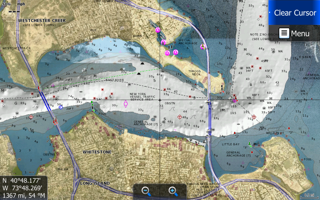
Problem. Why the darkened screen in the center. If it's to show very deep water./channel.. I can't follow the route chart line because it's to hard to see through the darkened channel area, especially, with sunglasses on.
This is or I should say, was, not on my E card. Not sure why this was changed. I've heard that creek channels are marked in a gold color,but what I'm seeing is a dark blue/gray color.
Any help would be appreciated.
Thanks,
Ernie
I need some help with the following question. I have a new HDS 12 Touch on the console and a HDS 9 on the bow. I cannot get the 9 to read my navionics chip. My chip is currently in the 12. Should the 9 be able to read it? My units transfers waypoints just fine. Or am I simply not doing something correctly.
Thanks in advance for any help!


You can share waypoints but not the map
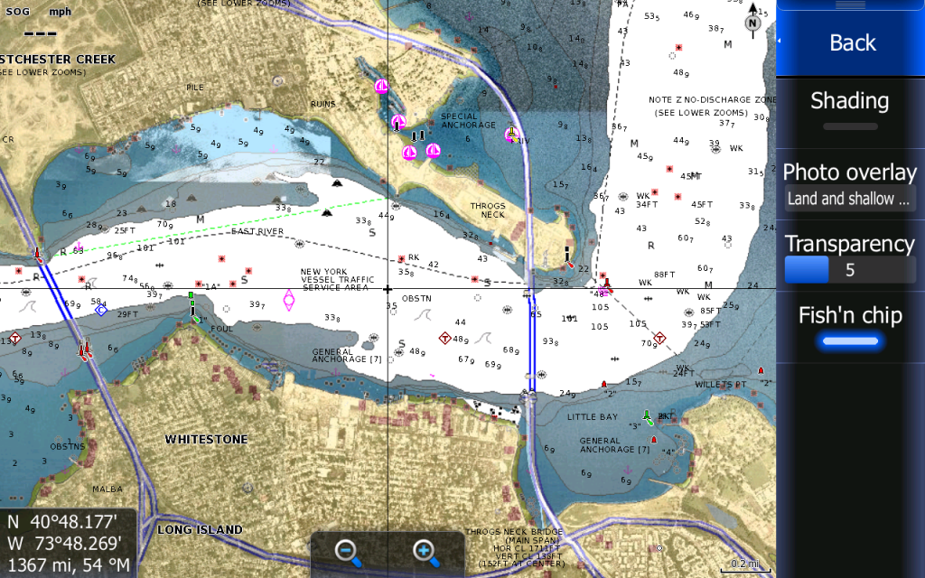
Try without: Shading and you can also play with: TransparencyOriginally Posted by nikldac

Maybe not exactly the area you are looking for but not far:
This is with shading on and depht security st at 30ft. on a Platinium (I don't have a Gold but I'm sure that you will be happy with a P+)
This one without shading:
Thank you Wallyandre. That is exactly what I was looking for. Is the web app map on Navionic's site what the Gold will look like? I was just trying to compare the two.
Yes
you guys are busy and Wally, Thanks man!!!
Boogie: yes go to www.navionics.com and check out the viewer. you can look at any lake in the USA.
Schleprock: I know barnegat bay well. My other suggestion about Platinum Plus... it has more advnaced contours offshore and in some areas one foot contours in the bay. Now with that being said, Sandy has changed much of that however we will have an initiative sometime this summer to remap the area. This is only on P+. So aside from Sat image and 3D, this for fishing will be very valuable to you.
nickaldac: do you have Sat overlay on by chance? maybe set up for full land and sea or just shallow water? If not can you post a pic and I can find out.
Rudy: Question back at you: will it not read while its plugged into the 9 or you are trying to network? The HDS systems wont network and share chart data if thats the case. Need two charts. If its that it is not reading the chip when plugged in, then we need to find out why for you.
Elite 7 new software coming next week. This will help with some Elite updates and allow the Premium chart with one foot lakes to be read correctly
pmnav I love the new iphone app! I can see the creek and river channel in gold, I think its called seabed? How do I get that on my HDS 10?
Unfortunatly I can get it on my Touch 12! Would love to!
Chart Options [the soft key] Scroll down to settings enter Its the top one.
Thanks
Is the Navionics lake Platnium worth the extra money over the premium? I have looked at there web app and looked I the lake that is fish most. I have deciede to buy the Navioncs charts but I don't know if I should get the Platnium or the Premium. Any input would be appriciated.
I think you should look here and also scroll the lakes lists to see if you're lake in HD: Hotmaps Platinum | Navionics
Thanks, The lake I fish are in HD but don't know if the Platinum is worth the extra money. Do you use the extra features?


 Reply With Quote