Results 1 to 9 of 9
  1. #1
    Member
    Join Date
    Aug 2016
    Location
    Hopkinsville , Ky
    Posts
    410

    Using m360 with th minn kota heading sensor.

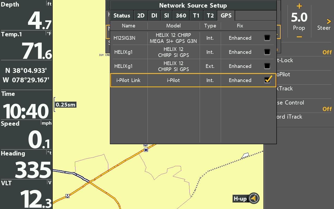
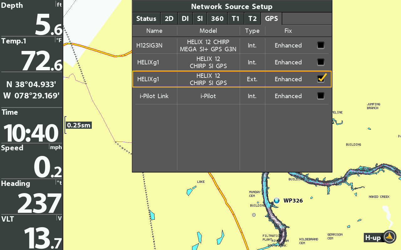
    Here is what I have minn kota terrova I pilot ( not I pilot link). Minn kota heading sensor. Helix 10 mdi G4N. Mega 360.
    The g4n is connected via a Ethernet cable to another helix 10 msi G1.

    I would like to be able to mark waypoints on the g4 using the m360 .
    If this is possible how do I do this?
    I thought it could be done using the MK heading sensor, but I can’t seem to get the g4 to recognize it .

  2. Member Wayne P.'s Avatar
    Join Date
    Jan 2010
    Location
    Charlottesville, VA
    Posts
    32,060
    #2
    To use the Minnkota GPS/Heading sensor, your iPilot has to be the LINK version which is an Ethernet connection.

    Then it would be subscribed to in the Network Source menu====


    Since you don't have LINK, you would need the AS GPS HS GPS/Heading Sensor and install that at the bow and connect it to a bow unit. Then that would be subscribed to in the Network Source menu====

    Last edited by Wayne P.; 02-19-2022 at 03:50 PM.
    Wayne Purdum
    Charlottesville, Va.
    Helix 12 MEGA SI+ G4N, Helix 15 MEGA SI+ GPS G4N
    SOLIX 12 SI/G3, Helix 8 MEGA SI+ G4N, Ultrex 80/Advanced, MEGA360,
    MEGA LIVE, LIVE TL, MEGA LIVE 2, Xplore 10

  3. Member
    Join Date
    Aug 2016
    Location
    Hopkinsville , Ky
    Posts
    410
    #3
    So then to do what I’m trying to do I would need the Humminbird external gps puck with heading sensor , and a Ethernet hub .
    Is this correct ?

  4. Member Wayne P.'s Avatar
    Join Date
    Jan 2010
    Location
    Charlottesville, VA
    Posts
    32,060
    #4
    Quote Originally Posted by Madeintheshade View Post
    So then to do what I’m trying to do I would need the Humminbird external gps puck with heading sensor , and a Ethernet hub .
    Is this correct ?
    I fixed the second screen show to show Ext as the GPS source which is the AS GPS HS.

    The AS GPS HS connects to the unit's NMEA0183 port and it powered by the unit. You just select it as shown in the second screen shot.
    Wayne Purdum
    Charlottesville, Va.
    Helix 12 MEGA SI+ G4N, Helix 15 MEGA SI+ GPS G4N
    SOLIX 12 SI/G3, Helix 8 MEGA SI+ G4N, Ultrex 80/Advanced, MEGA360,
    MEGA LIVE, LIVE TL, MEGA LIVE 2, Xplore 10

  5. Member
    Join Date
    Aug 2016
    Location
    Hopkinsville , Ky
    Posts
    410
    #5
    So then would my waypoints transfer on both units via the Ethernet cable between the 2 units ?

  6. Member Wayne P.'s Avatar
    Join Date
    Jan 2010
    Location
    Charlottesville, VA
    Posts
    32,060
    #6
    Quote Originally Posted by Madeintheshade View Post
    So then would my waypoints transfer on both units via the Ethernet cable between the 2 units ?
    No, waypoints are shared visually, not physically via Ethernet.
    If you want all waypoints in both unit's memory, you have to do that via memory card.
    Wayne Purdum
    Charlottesville, Va.
    Helix 12 MEGA SI+ G4N, Helix 15 MEGA SI+ GPS G4N
    SOLIX 12 SI/G3, Helix 8 MEGA SI+ G4N, Ultrex 80/Advanced, MEGA360,
    MEGA LIVE, LIVE TL, MEGA LIVE 2, Xplore 10

  7. Member
    Join Date
    Aug 2016
    Location
    Hopkinsville , Ky
    Posts
    410
    #7
    Wayne ,
    I think I’m understanding you
    If an external gps/heading sensor is attached through the NEMA port to the G4N , and a Ethernet cable is ran between the G4 and the G1 I can mark waypoints with the 360.
    Also waypoints waypoints marked on either unit will be visible on both units.
    Is this correct ?

  8. Member Wayne P.'s Avatar
    Join Date
    Jan 2010
    Location
    Charlottesville, VA
    Posts
    32,060
    #8
    Quote Originally Posted by Madeintheshade View Post
    Wayne ,
    I think I’m understanding you
    If an external gps/heading sensor is attached through the NEMA port to the G4N , and a Ethernet cable is ran between the G4 and the G1 I can mark waypoints with the 360.
    Also waypoints waypoints marked on either unit will be visible on both units.
    Is this correct ?
    The first generation Helix will not run or display MEGA 360 so it is impossible to mark and display waypoints on a 360 view with the G1.

    A waypoint is a GPS location, once created it will be displayed on the CHART view of any unit on the network. Makes no difference what view is used on the G4N to mark a waypoint. Just the Heading Sensor allows VIEWING and MARKING any waypoints on the 360 view.
    Wayne Purdum
    Charlottesville, Va.
    Helix 12 MEGA SI+ G4N, Helix 15 MEGA SI+ GPS G4N
    SOLIX 12 SI/G3, Helix 8 MEGA SI+ G4N, Ultrex 80/Advanced, MEGA360,
    MEGA LIVE, LIVE TL, MEGA LIVE 2, Xplore 10

  9. Member
    Join Date
    Aug 2016
    Location
    Hopkinsville , Ky
    Posts
    410
    #9
    Thanks Wayne !