Claiming they were not responsible for the collision.
http://www.wpsdlocal6.com/news....html


Claiming they were not responsible for the collision.
http://www.wpsdlocal6.com/news....html
They shouldn't need lights!!! They made it all the way to the bridge in the dark and stayed in the river channel the whole time...then they get to the bridge and are out of the channel??? I don't get it...I would think a boat that is carrying rockets for NASA would at least have a HDS10 on board!!!
They are trying to find a loophole.
So much for sonar and radar
I would guess that it is a mechanism for choosing the venue of all the lawsuits that are bound to follow.
<table width="90%" cellspacing=0 cellpadding=0 align=center><tr><td>Quote, originally posted by RangerRodney »</td></tr><tr><td class="quote">So much for sonar and radar
I would think that AIS would have helped avoid this as well.......but maybe it doesn't show navigational routes......
http://en.wikipedia.org/wiki/A...ystem
I agree, looking for a loop hole..
I remember reading that the faulty lights were on the north side of the bridge, therefore would not even have been visable if they had been working.
Sadly, this guy will probably win due to precedent.
Brett Graham
Louisville, KY
L\'raisin Anglers
Isn't there marker bouys every so often marking the channel?
I believe they were in the channel, but way off to one side.
<table width="90%" cellspacing=0 cellpadding=0 align=center><tr><td>Quote, originally posted by CatFan »</td></tr><tr><td class="quote">I believe they were in the channel, but way off to one side.</td></tr></table>
No way they were in the channel, where they hit could not be any deeper than 20 to 25 feet at the most.
<table width="90%" cellspacing=0 cellpadding=0 align=center><tr><td>Quote, originally posted by RangerRodney »</td></tr><tr><td class="quote">
No way they were in the channel, where they hit could not be any deeper than 20 to 25 feet at the most.</td></tr></table>
+1
They were one full section of bridge OUT of the channel.
<table width="90%" cellspacing=0 cellpadding=0 align=center><tr><td>Quote, originally posted by Longrodder »</td></tr><tr><td class="quote">They were one full section of bridge OUT of the channel.</td></tr></table>
Is that all? By looking at the pictures they were 3 pillars over from the channel.
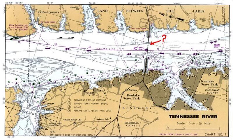
I was under the impression they hit the span the arrow is pointing to on this chart, which is the second span from the east side as marked on the chart. It shows in the channel as far as I can see.

I would think anyone with a gps/navionics chart could stay in the channel even in pea soup fog. Surely this ship had something even better.
I'm pretty sure he hit the side closer to Ken Lake not LBL.

<table width="90%" cellspacing=0 cellpadding=0 align=center><tr><td>Quote, originally posted by TR21Bassin »</td></tr><tr><td class="quote">I'm pretty sure he hit the side closer to Ken Lake not LBL.</td></tr></table>
Fenton side, and my best guestimate by looking at my Navionics computer app is that it is about 20 ft deep in that location at summer pool.
They hit the second span with overhead superstructure form the LBL side
<table width="90%" cellspacing=0 cellpadding=0 align=center><tr><td>Quote, originally posted by Daniel »</td></tr><tr><td class="quote">I would think anyone with a gps/navionics chart could stay in the channel even in pea soup fog. Surely this ship had something even better.</td></tr></table>
That's the bottom line. Even my handheld Garmin would have easily let me find the right one, even in total darkness.
<table width="90%" cellspacing=0 cellpadding=0 align=center><tr><td>Quote, originally posted by fish »</td></tr><tr><td class="quote">
Fenton side, and my best guestimate by looking at my Navionics computer app is that it is about 20 ft deep in that location at summer pool. </td></tr></table>
Well that's even more damning to the pilot. A Tennessee river pilot would know that 16ft of water wasn't mid-channel that close to the dam. I'd think a sonar reading of 16ft on a ship that has a design draft of 14ft would be enough for the Oh $#!+ alarm to go off.
Something isn't right. No competent pilot is going to do that. Radar could fail, bridge lights could fail, blinding fog, plague of locusts, it doesnt matter. They aren't going to guess which is the right span.


 Reply With Quote