-
Garmin's new 1242xsv touch
Major difference is single channel chirp vs dual channel chirp on the 7600 series
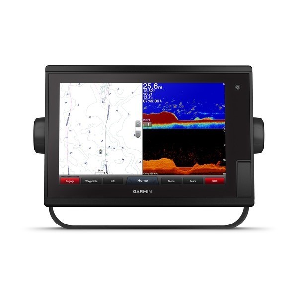
Garmin GPSMAP1242xsv Touch 12" Chartplotter/Sonar Combo Preloaded with BlueChart g2 charts and LakeVü HD
( New touch also in: 1242, 1222, 1222XSV)
Model: 010-01917-13
1 kW single-channel CHIRP sonar provides crystal-clear images with remarkable target separation and definition
ClearVü and SideVü scanning sonars deliver nearly photographic images of what is below, around and to the sides of your boat
Fully network capable to build your marine system; network sharing allows you to share data among all compatible units connected to the network
Compatible with optional BlueChart® g2 Vision® HD charts and LakeVü HD Ultra maps for Auto Guidance and more
Supports Panoptix all-seeing sonar
Preloaded BlueChart® g2 charts and LakeVü HD maps include market-leading features such as Depth Range Shading and Shallow Water Shading
GPSMAP 1242xsv Touch is the ideal choice for the coastal fisherman who wants to step up to a big, bright 12" touchscreen combo. It includes built-in 1 kW single-channel CHIRP plus ClearVü and SideVü scanning sonars, and its compatible with Panoptix all-seeing sonar. Preloaded BlueChart g2 HD charts and LakeVü HD maps provide market-leading features such as Depth Range Shading and Shallow Water Shading. It features full networking capabilities to build your marine system with radar, autopilot, sonar modules and sensors. It also supports FLIR cameras, GRID keypad, GXM 53 marine weather receiver, FUSION-Link audio system, VIRB® camera streaming and more. Network sharing allows you to share data among all compatible units connected to the network. Plus, it has built-in Wi-Fi® to support the ActiveCaptain app.
Access some amazing sonar capabilities all you add are transducers. GPSMAP 1242xsv Touch comes with built-in Garmin 1 kW CHIRP sonar and CHIRP ClearVü and SideVü scanning sonars. It even supports Panoptix all-seeing sonar, premium Garmin sonar modules and a wide range of transducers (sold separately).
You get both LakeVü HD inland waters mapping and BlueChart g2 coastal charts covering the coastal U.S.
LakeVü HD provides highly detailed freshwater maps that include 17,000+ U.S. lakes, rivers and reservoirs. Included in those are more than 13,000 HD lakes with up to 1 contours. Upgrade to LakeVü HD Ultra with Max Def Lakes to access the Auto Guidance feature, sonar imagery and more.
BlueChart g2 covers the East Coast, West Coast, Gulf of Mexico, U.S. and the Canadian side of the Great Lakes. It includes basic coastal charts, tidal and current stations, depth contours, IALA nav symbols and fishing charts. Upgrade to BlueChart® g2 Vision® HD to access Auto Guidance and more.
Instantly create personalized HD fishing maps onscreen with 1 contours. Tailor them to fit your needs. These are your maps you own them. Keep the data to yourself, or share it with the Quickdraw Community.
The touchscreen combo is fully networked using the Garmin Marine Network, NMEA 2000®/NMEA 0183, J1939 and built-in ANT® connectivity, so you can build your marine system with radar, autopilot, sonar modules, instruments, sensors, FLIR cameras, FUSION-Link, VIRB camera streaming and more. Network sharing allows you to share data among all compatible units connected to the network.
Built in Wi-Fi gives you access to the free all-in-one ActiveCaptain app, so you can manage your marine experience from nearly anywhere. It creates a simple yet powerful connection between your compatible mobile device and your Garmin chartplotter, charts, maps and the boating community. Wherever you are, youll have unlimited access to your cartography, the ability to purchase new maps and charts and access to the Garmin Quickdraw Contours Community. Stay connected with smart notifications on your chartplotter screen. You can also plan a trip or prefish a lake, and ActiveCaptain will automatically sync with your chartplotter. Even get notifications for software updates, and decide when to download them on your device.
To help you gain a wind-maximizing competitive edge, your chartplotter features a prerace guidance page. It shows your virtual starting line along with data fields showing laylines, time to burn before the start and a race timer that can be synchronized across all your networked Garmin GPS products. In addition, other supported sailing features include an enhanced wind rose, heading and course-over-ground lines, set and drift, true and apparent wind data and more.
The fast, responsive 10 Hz GPS and GLONASS receiver refreshes your position and heading 10 times each second to make your movement on the screen more fluid. Now, its quick and easy to drop up to 5,000 accurate waypoints and find your way back to them.
Auto Guidance is for planning purposes only and does not replace safe navigation operations
Specifications
General
Display type WXGA display
Display size 10.3" x 6.4" (26.2 x 16.3 mm)
Display size 10.3" x 6.4" (26.2 x 16.3 mm)
Display resolution 1280 x 800 pixels
Antenna Internal or external over NMEA 2000
Mounting options Bail or flush
Receiver 10 Hz high-sensitivity
Maps & Memory
Accepts data cards 2 SD cards
Waypoints 5,000
Routes 100
Track log 50,000 points; 50 saved tracks
Preloaded maps BlueChart® g2 (coastal maps) and LakeVü HD (inland maps)
Outdoor Recreation Features
Tide tables Yes
Chartplotter Features
Garmin Radar compatible Yes
Garmin Sonar compatible Yes (built-in)
Garmin SmartMode compatible (customizable monitor presets) Yes
Supports AIS (tracks target ships position) Yes
Supports DSC (displays position data from DSC-capable VHF radio) Yes
Garmin Meteor Audio System compatible Yes
Supports FUSION-Link compatible radios Yes
GSD Black Box sonar support Yes
GCV Black Box sonar support Yes
BlueChart® Mobile (planning) compatible Yes
Garmin Helm compatible Yes
GRID (Garmin Remote Input Device) compatible Yes
Wireless remote compatible Yes
Sonar Features & Specifications
Dual-frequency (50/200 kHz) sonar capable Yes
Dual-beam (77/200 kHz) sonar capable Yes
Frequencies supported Traditional: 50/77/83/200 kHz
CHIRP (low, medium, high)
ClearVü/SideVü (260/455/800 kHz)
(dependent on transducer)
Transmit power 1 kW traditional; 1 kW single channel CHIRP
CHIRP sonar technology Yes (Built-in)
ClearVü Yes with CHIRP (built-in)
SideVü Yes with CHIRP (built-in)
Maximum depth 5,000 ft at 1kW (depth capacity is dependent on water bottom type and other water conditions)
Bottom lock (shows return from the bottom up) Yes
Water temperature log and graph Yes
Sonar recording Yes
Sonar history rewind Yes
Connections
NMEA 2000® compatible Yes
Transducer pin numbers 12
NMEA 0183 input ports 1
NMEA 0183 output ports 1
Video input ports 1 BNC
Video output ports 1 HDMI
Wireless connectivity Yes
J1939 Yes
Garmin Marine Network ports 2
Input Voltage 12vDC
Input Draw Max power usage at 10 Vdc: 36.5 W
Typical current draw at 12 Vdc: 2.4 A
Max current draw at 12 Vdc: 3.0 A
Dimensions 13" x 8.9" x 3.1" (33.0 x 22.6 x 7.9 cm)
What's in the Box:
GPSMAP 1242xsv Touch chartplotter
Power/data cable
NMEA 2000® T-connector
NMEA 2000 drop cable (2 meters)
Bail mount kit with knobs
Flush mount kit with gasket
8-pin transducer to 12-pin sounder adapter cable
Protective cover
Trim piece snap covers
Documentation


 Reply With Quote