Thanks for the information, Perhaps they'll throw us a bone and provide some way to calibrate using the offset. I guess it might just open another can of worms thoughOriginally Posted by cgesling


Thanks for the information, Perhaps they'll throw us a bone and provide some way to calibrate using the offset. I guess it might just open another can of worms though
That’s amazingly bad info out of a pro staff guy.
I thought so also
What's the amazingly bad info?
I don't think he was referring to you, he was talking about the guy that was saying the offset was irrelevant and that when using trackback there is no offset,but I think maybe he just miss understood and was thinking about the offset on screen,not really sure. I definitely think your information is good though
Didn't mean to open a can of worms here,was just curious if we'd ever come up with a way to calibrate the GPS to the transducer location.
As another Prostaff guy I have set these up solely because of the problems discussed here. Years ago we did tests using both GPS and the old orange markers and string weights. I found that in most cases the angler had no idea where his transducer was "looking". Where the picture on the screen actually was in relation to the marker or GPS. This is a true giant can of worms and not sure there is an absolute answer..I can say for sure that ONLY some testing on each boat will help. Case in point. if a screen image seen is marked with a waypoint...Bing..that is the spot. Prob not. What was marked on screen is the location of the GPS antenna (whether Point 1 or internal) at that point in time. Was the transducer tilted in any direction? If so then the location is likely not correct. In calm water, no wind or current...First we had to establish with a string and mass of lead-weight that the target in 20 ft of water was shown on the scope on the screen..NOT a scrolling picture of past image. Real instant pic as close as possible. That would somewhat say that the transducer is looking straight down and not tilted X degrees due to bow rise..or off to the side due to misalignment at installation. WAY too much theory here to print but establishing something that is a known fact is the place to start. IS what you see on the screen exactly under the ducer. That is THE goal here.
The guys with the glassed in transducers have yet another problem in that it is not adjustable in any direction so they are stuck..so to speak BUT, probably with testing it out can establish some idea of accurate location simply from experiencing it in real time.
So, establish the straight down GPS puck to transducer....then test from there. Depth of water and degree of tilt could put that stump 20 feet (example) from the actual marked transducer/gps spot. Only testing will help you get a closer and a more reasonable idea of what your setup is showing. Casting to the "spot" with a couple ounce weight on braid to try to hit it should help answer the puzzle.
Tommy
Prostaff
Lowrance/Navico
Last edited by prostaff1; 06-15-2019 at 10:02 AM.
This may help.... I will add - After using a digital level to set my transducers. Being off by 10-15 degrees is huge. Just eyeballing the water line on the side of the boat and setting the transducer angle to that will get you within 2-3 degrees. Setting the digital level on the deck and accelerating to 5-6 mph only resulted in a angle change of 3-4 degrees at most. My boat idles at just about dead on 3mph.
Last edited by yupitsme; 06-15-2019 at 10:37 AM.
Nice but does not address the question and subject of target accuracy, tilt and misalignment. Again, the assumption seems to still be that the cone is perfectly straight down from the transducer, thus the screen picture is perfectly aligned within the cone. Very unlikely.
Simple explanation.....think of the transducer as a digital camera with zoom lens..connected to your screen with GPS location marking at the camera.
Pointed straight down the ratio is abt 1/3 diameter to water depth..So, in 18 feet of water you have abt 6 foot circle.
Now the picture on the screen. if you have one...is ok if the camera lens is straight down and you see the target at that point.
BUT, if you tilt the camera so you see forward say 10%..(Transom down, bow rise) to some degree....now what is in the eye of the camera and shown on the screen?? WAY off...then the waypoint button is pushed... BUT, you have just marked the GPS corrdinates at the puck location OR the internal unit location on the console... and NOT at the location as seen by the camera...That target is a considerable distance away from the camera view and GPS location marker...
So all bets are off AFTER this misunderstanding as to accuracy of target vs GPS location.
Tommy
Prostaff
Lowrance/Navico
Last edited by prostaff1; 06-15-2019 at 10:52 AM.
I don't necessarily disagree with your stated position. But you seem to want to take some set of arbitrary variables and chunk'em out the window and replace them with your own set of equally arbitrary variables and then some how try to justifiy why your arbitrary set is more valid that the first. I'm saying the fore/aft angle of the transducer is seldom off by the numbers you're presenting. And the port/startboard level is, in most cases waaaay less than 3-4 degrees.
Just some info on actual on water research we did to establish the relationship of the transducer look angle to the actual target. You have no data on how much tilt any transducer has, differences in bow rise on any particular boat is pure guesstimation...there is no set data or anything to support what is an average. Every case is different and WHY I suggested if an angler is interested...do the experiments themselves.
So, do with it what you will.
Tommy
Prostaff
Lowrance/Navico
Any idea how the cone on the 3 in 1 compares to the cone on a 2d/downscan transducer compares? trying to decide if there is any benefit to swapping the the downscan transducer on my TM with a 3 in 1
To answer your question you need to pull up the engineering diagrams and compare side by side for a specific water depth...then decide what suits your needs the best. The issue is not about cone type or size. There are a zillion engineering data charts out there to show and explain. Problem here is the diagrams offered show an exact cone with sharp terminating edges. Not that way technically...dealing with half power beamwidth, the tapering power reductions etc. Too much for here. It is all available on line to study in depth.
I think this discussion is about locating a target seen on the screen and the method to mark it so it can be located again if using GPS, either a puck on transom or internal to the HDS unit.
Creating a "known" view (spot) is required for all subsequent discussion. The transducer is like a camera lens and it puts on the screen where you have it pointed..on transom GPS marking is totally different from assuming screen marking accuracy
When a GPS waypoint is made it is for that EXACT and "only" spot on earth..via satellite...at that puck...Not from the screen view. The Lat/Lon numbers on the screen are for ONE spot and the angler has to determine what he marked and that relationship. You can tilt the transducer in any direction to "see" a target in the nearby surrounding area but it is likely not under where the GPS marked it. Determining the relationship between the GPS mark and the target is the goal. How each angler determines that is their personal choice and experience.
Everyone prob has different methods but the final answer is if your method puts you back on the spot/target..then that is the correct method for you. Others may vary
Being old school, I still think a tried and true method to mark a stump is the orange float/ string and lead weight markers. "IF" you know the transducer is truthfully pointing straight down. But that's just me. :))
Then the discussion of whether to throw it over your head over transom as you pass the target..or drop it next to drivers seat ...and WAIT...the offset idea.
Ideas which will cause your Brain to explode eventually. :)) If you can find what you marked you win...done!!
Tommy
Prostaff
Lowrance/Navico
I agree with Tommy in that IF it works for you and you are confident, USE IT!
This is what I use.....My Point-1AP uses 12 satellites and of the 12 it uses the strongest 3 to triangulate my position. My position as shown on my graph is the cursor. The Point-1 has no known relationship to the sonar transducer and maybe the best way to see this is to remind ourselves the cursor is in the middle of the chart page and my structure is at the leading edge of my sonar page. You can not place a waypoint over structure unless you have previously passed over it with it being within your transducer cone angle. Why? Because the MFD has no way of knowing it is there. Say 10 minutes goes by and its slow fishing, you start 'Track-Back'ing and see something you need to mark. Using your StructureScan page you can place a waypoint on the structure and at the very least, know your waypoint is on the correct side of your boat. If you mark the same spot using your 2D you will only be in the general area. This is the way I do it and I always find my target when I go back.
Think of how wonderful it would be IF your MFD created a grid on your screen from info transmitted by your transducer, then, you calibrated your Point-1 TO the MFD grid. Wow, we could make perfect location spots sans EPE, make adjustments to water level, and leave no fish to swim free again.
Tommy and I aren't the onlyest guys using this method..
Edd
I know that you believe you understand what you think I said, but I'm not sure you realize that what you heard is not what I meant.
Exactly
Ok, I had to draw a picture, and will post my thoughts. All this talk about placement of the GPS receiver, to me, seems somewhat irrelevant.
US Gvt commits Average User Range Error of <= 25.6ft 95% of the time
The actual performance is usually way better than spec.
According to this article, the Global Average User Range Error was <= 2.9 ft on May 11, 2016.
So, to make it easy, lets all agree that the BEST you should expect is accuracy to within 3 ft horizontally (we can argue this or not...but for the rest of this discussion, lets assume it).
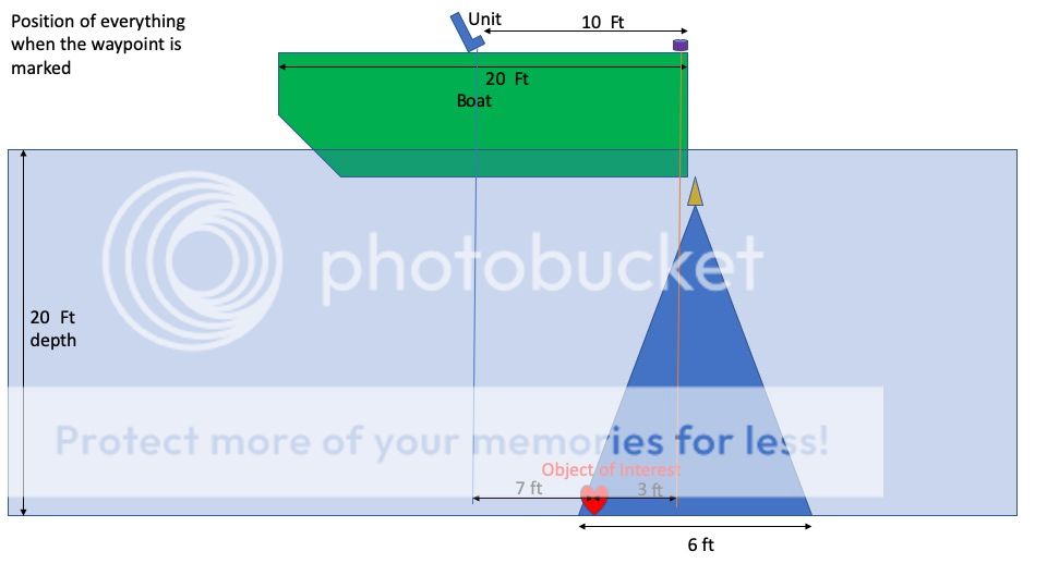
I drew up thee pics, first, lets look at the boat the first time it travels over the object of interest.
I Drew both the unit located at the helm, and a GPS puck over the transducer.
I assumed a 20 ft boat, and the unit was 10 ft from the transom.
I assumed 20 ft of water, and a 6ft cone diameter at the lake floor.
In this case when the boat first starts getting a return from the object of interest, it is:
- 3ft in front of the transducer
- 3ft in front of the GPS Puck
- 7ft behind the unit at the helm.
If you hit the waypoint flag at that instant, you would record the above errors, if you waited a bit till the object was right under the transducer, then you would get it right under the transducer, and 10ft from the unit at the helm.
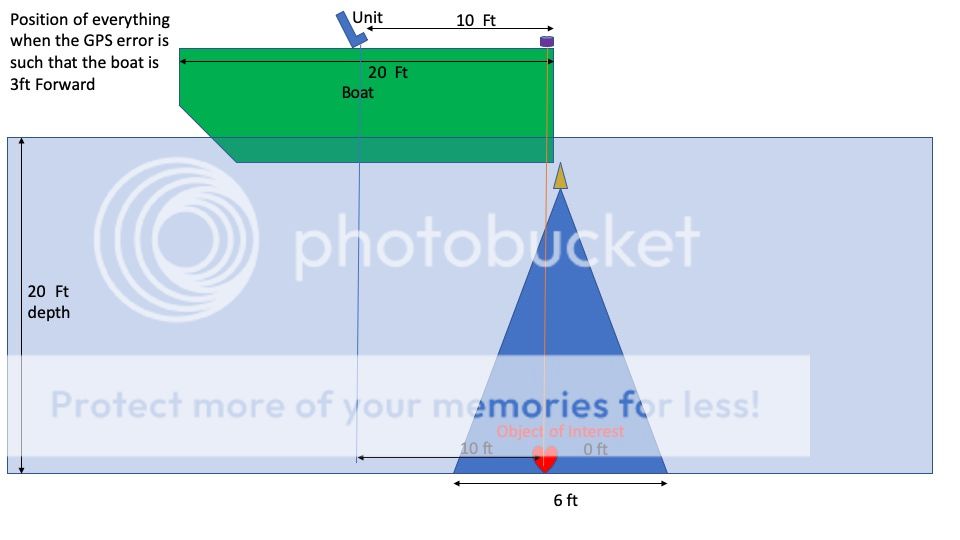
Now, if all were perfect, no GPS errors, and you traveled back to that spot later, using the same boat, you would get the same picture and the same error over again.
However, on a different day, you could get the 3ft GPS induced range error, so lets look at it if the range error was such that it was off so the boat was 3ft forward of the last time you went over your favorite object. In this case, you would get:
- The Object under the transducer
- The object right under the GPS Puck
- The object 10 ft behind the unit
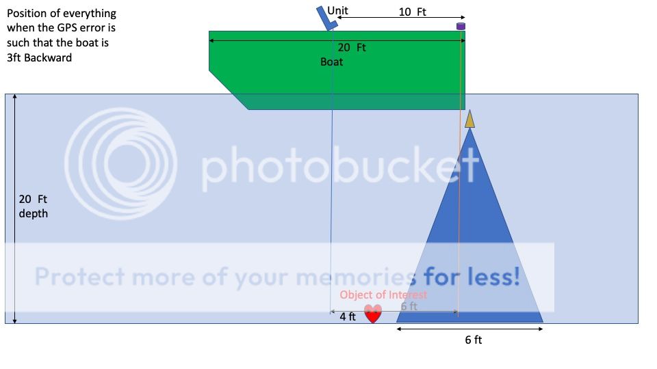
Now, if we assume the error was off in the opposite direction, then:
- The object would be 6 feet in front of the transducer (and not showing on your sonar because it is not in the cone)
- 6ft in front of the gps puck
- 4ft behind the unit.
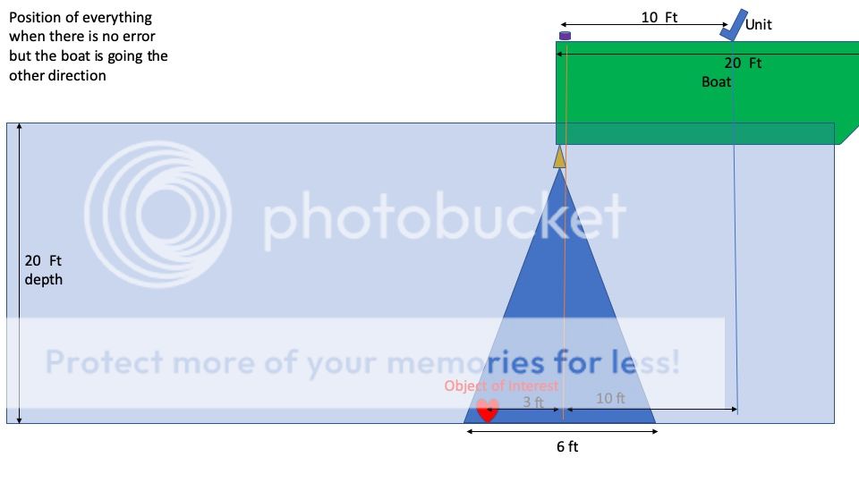
Now, if we look at there being no GPS error, but approaching the object from the other direction, when we get the puck exactly to the waypoint, note the object of interest is still in the cone, but just barely. But, we would have started seeing the object in the sonar 6ft sooner, as the object is now at the back of the cone vs. the front when traveling in this direction. Here the object of interest is now:
- At the far back of the Sonar cone
- 3ft behind the GPS Puck
- 10 ft behind the unit
Oh, and if you start tilting the transducer, listing the boat, etc, things could get worse...but, if you always use the same equipment (same boat, same speed, same weight distribution) then you at least minimize that error, at least until you approach from the other direction, then it rears its ugly head again.
My net, use waypoints to get you in the area of where your beloved object is, but you have to use your sonar, and some other way of marking and holding the spot if you are concerned within a circle less than about 10ft.
Besides, I know you bass fishermen like to brag, but none of you can consistently cast into a 3 ft circle
Last edited by MichaelJ3; 06-19-2019 at 02:28 PM. Reason: added editorial comments about tilt and list
2016 Ranger 1850 LS Reata / Merc 150 4s / SmartCraft / Lowrance HDS Carbon SS3D
Nice write up, So basically, in most cases, no need for a puck? oh and by the way I can probably consistently cast into a 1 foot circle :P
Well, the puck will give you heading, pitch, and roll, so there are some advantages....
2016 Ranger 1850 LS Reata / Merc 150 4s / SmartCraft / Lowrance HDS Carbon SS3D
That is a LOT of really good work. So kudos, wish I knew how to create those images.
In the real world however your boat is NOT perfectly parallel with the bottom. Bow rise is always there to varying degrees...the angles shown here are perfect 90 degrees to bottom....
almost impossible in real life...assuming the transducer is in fact seeing straight down..again not likely. So on paper what you show is excellent and well done.
Figure in bow rise, transducer tilt both forward and port to starboard....even a minimum of just a few degrees...and all of that is out the window.
SO, for discussion example...my boat using a Suunto clinometer or Iphone app, pretty accurate,... bow rise at slow idle is 6 degrees, say my transducer mount is in error...slightly tilted toward bow...couple, maybe three degrees which s a VERY easy error...Now this diagram which is great on paper is now useless since we are looking at a target way in front of the hypothetical "straight down" 90 degree perfect transducer view.
That is my only point in saying that each angler needs to test what he has to consistently locate the target...by whatever means. But to rely on perfect angled hypothetical scenarios is questionable on the water. It just is not like that at all. Way tooooo many variables to assume anything is dead on accurate. I said in a prior post this will make your brain explode...as most can see it is a VERY difficult set of parameters to try to justify an absolute answer.
My money goes on the old orange float markers. :))) I think with technology now, to drop the floating marker ON the target (with double lead weights to counter current etc) that we could idle back over the marker and put the GPS puck right on top of it...and mark it with pretty good accuracy. Assuming the transducer is pointing perfectly straight down, then would lessen the "offset" somewhat.
This really is a brain twister since everything on the water is always inconsistent. Each angler, each boat, different installations etc. Very tough, if not impossible to figure it accurately and dependably.
Tommy
Prostaff
Lowrance/Navico


 Reply With Quote