Well I paid for a bunch of it. Mapping chips, waypoint chips and a whole bunch of guide trips


Well I paid for a bunch of it. Mapping chips, waypoint chips and a whole bunch of guide trips
Can I download waypoints from a 73dv to a sd card and up load that card to a 7608xsv, or do I have to go though all the Homeport stuff?
Export or save them to the card in the 73. You should be able to then just copy them to the sd card you use in the 7608 or put that card in the 7608 and import them.
Smokercraft Phantom 202 Yamaha F115/Merc 9.9
Garmin 7610xsv/GT51M-TM/Panoptix PS21/LiveScope
Why am I hanging out here when I could be fishing.....

Now if we could only get Homeport to support depth shading and route creation like the lake vu ultra has it would be one hell of a program
How do I convert lowrance .usr files to .gpx so I can transfer waypoints from my old lowrance to new garmin?
I thought some Lowrance units would export the files as GPX? If not, google GPS Babel. Its a program for converting GPS files into different formats.
Smokercraft Phantom 202 Yamaha F115/Merc 9.9
Garmin 7610xsv/GT51M-TM/Panoptix PS21/LiveScope
Why am I hanging out here when I could be fishing.....
**delete**
Last edited by Legend LE-195; 02-03-2017 at 11:26 AM.
I've converted my waypoint file using GPS Babel from lowrance USR to GPX XML. Now copying data from my memory card to my garmin following the path User Data > Manage Data > Data Transfer I have two options, Merge from Card or Replace from Card, which do I pick?
I would merge first. Then check for duplicates and delete those. If you replac e, you might loose some of the ones already on the device.
Smokercraft Phantom 202 Yamaha F115/Merc 9.9
Garmin 7610xsv/GT51M-TM/Panoptix PS21/LiveScope
Why am I hanging out here when I could be fishing.....
The device is brand new I've not installed a waypoint or track on it yet so I guess maybe it doesn't matter which, I was just confused why there were two options and wasn't clear on the difference. I guess one adds data without affecting current data in memory while the other wipes old data completely out and replaces it with whats on the memory card?
Exactly
Smokercraft Phantom 202 Yamaha F115/Merc 9.9
Garmin 7610xsv/GT51M-TM/Panoptix PS21/LiveScope
Why am I hanging out here when I could be fishing.....
After every trip I export from my unit to the card. I then make my name changes and icon changes in homeport and export back to the card and save on top of the original file. I then delete all waypoints from my unit and then insert the card and choose replace.
Troy, when you do that, do the icons in Homeport get changed in the MFD? I cant seem to get the ones I pick in Homeport to stick.
Smokercraft Phantom 202 Yamaha F115/Merc 9.9
Garmin 7610xsv/GT51M-TM/Panoptix PS21/LiveScope
Why am I hanging out here when I could be fishing.....
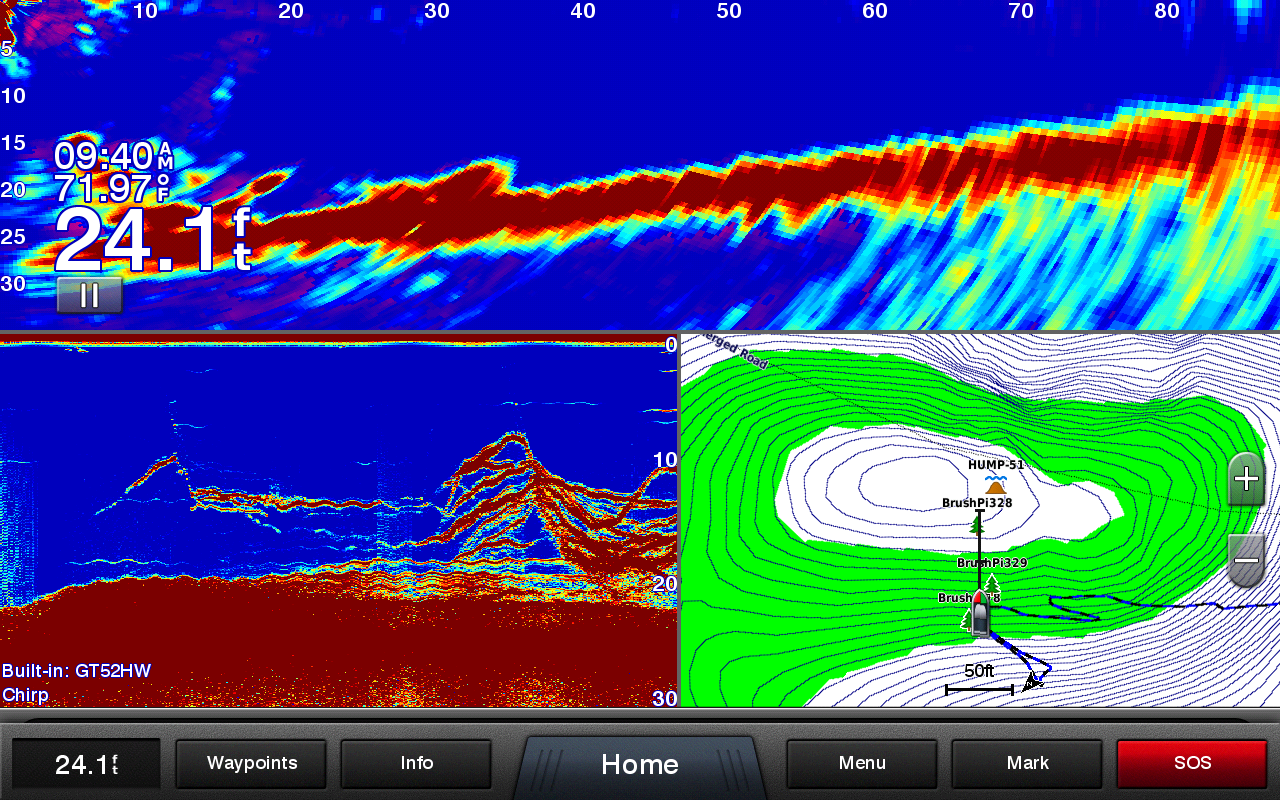
I've figured out which ones in homeport work with the 7600 series. Most of my waypoints are brush piles and timber so I use the single gree tree for brush and the single blue tree for timber. If you set them for something the unit doesn't support it changes the to the standard .
You can also see the hump icon here
Sure would be nice if they made that easier to figure out or better yet, standardized them between Homeport and the MFD's so they matched up.
Smokercraft Phantom 202 Yamaha F115/Merc 9.9
Garmin 7610xsv/GT51M-TM/Panoptix PS21/LiveScope
Why am I hanging out here when I could be fishing.....
Agreed
My local lake got super low this winter and I went and walked areas and created GPS points on my cell phone app. Can I manually add these gps coordinates with Homeport and place on Map so I can then load into my Echomap unit?
Thanks
I have a question about tracks. When I downloaded my tracks from my EchoMap 73sv it shows up in homeport as ONE big track. There are some that I would like to keep and some I would like to delete to declutter my history. Is there a way to select specific parts of a track for deletion. Right now if I try to select a track it selects the whole string.
jbird68
Morrison, IL
2006 Alumacraft Navigator 165 CS
2006 90 HP Mercury Optimax
80# Minn-Kota Terrova w/ iPilot
I changed the format on my garmin unit to the format of a map that I got a bunch of waypoints off of decimal decimal, now when I transfer my waypoints to home port it shows some of the way points on land. how can I fix this? also any changes I make while in HP will they automatically be on my unit when I put my SD card back in?


 Reply With Quote