Lake Hoston, I think it's listed as Houston, Harris on the Lakemaster list!Originally Posted by Doug Vahrenberg


Lake Hoston, I think it's listed as Houston, Harris on the Lakemaster list!
Another question I have is can you do overlays on a lake that is not in HD?

Here are some examples

--
http://www.dougvahrenberg.com/
BASS Central Open- Competitive Bass Angler and Humminbird Guru
Visit my website to learn about my sponsor's products, fishing tips and techniques.
Learn More About Humminbird Side Imaging Visit: http://groups.yahoo.com/group/sideimaginggroup/
Doug you're the "MAN"!
I'm thinking i'm going to have to go with a through hull ducers but will see how this Trans mounted dicer works 1st. Install on a 186 Dargel Skout tunneled, gonna see if I can run my jack plate all the way up & get a good reading.
Here's a post I put on a few other boards.
Well got it all install & played with it a while in simulation, got my settings where one of the pros says it works best. (Doug V.) Here's a couple pics

Lookin Good!
--
http://www.dougvahrenberg.com/
BASS Central Open- Competitive Bass Angler and Humminbird Guru
Visit my website to learn about my sponsor's products, fishing tips and techniques.
Learn More About Humminbird Side Imaging Visit: http://groups.yahoo.com/group/sideimaginggroup/
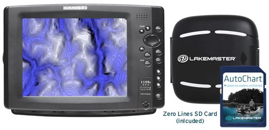
LakeMaster® Introduces AutoChart™ User-Generated Mapping ProductsNew products let anglers chart unmapped waters and scrutinize ‘spot-on-the-spot’ locationsLittle Falls, MN (July 5, 2013) - Imagine being able to map your favorite uncharted bodies of water, revealing fish-holding structure in stunning contour lines, finally giving you a visual of what’s below. And what if you had the ability to survey your own current ‘spot-on-the-spot’ locations for the ultimate in one-of-a-kind, high-definition charts?
Now imagine a product designed by anglers and for anglers who understand the sensitive nature of this kind of information and cherish their favorite lakes and fish-holding spots the way you do.
Enter LakeMaster® AutoChart™ and AutoChart PRO™.
Anglers now have the ability to chart private, public and hard-to-reach waters far off the radar of DNR surveys and commercially available paper maps and digital GPS charts. That means you can finally map your own favorite lakes, reservoirs, farm ponds, ever-changing rivers—even off-the-grid Canadian waters.
Then, once finished creating your own custom map you’ll get use of LakeMaster’s three key patented features of Shallow Water Highlight, Depth Highlight and Water Level Offset on your map. Combine your map with Minn Kota® iPilot® Link® and you can set your trolling motor to follow your custom contours! You can also offset these contour lines by any value you choose and automatically follow with your boat.
Available for a one-time purchase price, no subscription or pay-by-the-lake fees, AutoChart and AutoChart PRO put the power in anglers’ hands, not the company behind the product (or fellow anglers). The maps you generate with AutoChart will never turn up on the web or become someone else’s property. You create it, you own it.
Another competitive advantage; anglers will delight in the ease of operation. Maps are created in three simple steps for immediate use, no waiting to upload data to a server somewhere in the clouds.
FEATURES
AutoChart™
- Create custom maps using the AutoChart SD card featuring over 2 million lakes with Zero Lines for your Humminbird® and computer
- Patented LakeMaster features compatible with AutoChart generated contours: Depth Highlight; Water Level Offset; Shallow Water Highlight
- Follow the Contour functionality of Minn Kota® I-Pilot® Link® by loading digital maps created in AutoChart into your Humminbird
- Satellite image overlay
- Works with all LakeMaster compatible Humminbird units
AutoChart™ PRO
- Create custom maps using the AutoChart SD card featuring over 2 million lakes with Zero Lines for your Humminbird® and computer
- Patented LakeMaster features compatible with AutoChart generated contours: Depth Highlight; Water Level Offset; Shallow Water Highlight
- Follow the Contour functionality of Minn Kota® I-Pilot® Link® by loading digital maps created in AutoChart into your Humminbird
- Satellite image overlay
- Bottom Hardness indicating various levels of bottom composition
- Merge Side Imaging Mosaic data onto the map for 3D visualization of fish-holding habitat -- the ultimate in coverage
The official product launch is scheduled for 10:30 am on Wednesday, July 10, at ICAST booth #122.
For more information visit lakemap.com, contact LakeMaster, 59 East Broadway, Little Falls, MN 56345, or call 320-632-6300.
ABOUT JOHNSON MARINE ELECTRONICS, INC.
Johnson Outdoors Marine Electronics, Inc. a wholly-owned subsidiary of Johnson Outdoors Inc. (Nasdaq:JOUT), consists of the Humminbird®, LakeMaster®, Minn Kota® and Cannon® brands. Humminbird is a leading innovator and manufacturer of fishfinders, fishfinder/GPS combo units, ice flashers and digital depth gauges. LakeMaster® is the premier brand of high-definition electronic fishing charts. Minn Kota® is the world’s leading manufacturer of electric trolling motors, as well as offers a complete line of shallow water anchors, battery chargers and marine accessories. Cannon® is the leader in controlled-depth fishing and includes a full line of downrigger products and accessories.
MEDIA CONTACTS:
Jim Edlund
Traditions Media, LLC
jim@traditionsmedia.com
612.481.7396
Cory Schmidt
Traditions Media, LLC
cory@traditionsmedia.com
218.821.4148
--
http://www.dougvahrenberg.com/
BASS Central Open- Competitive Bass Angler and Humminbird Guru
Visit my website to learn about my sponsor's products, fishing tips and techniques.
Learn More About Humminbird Side Imaging Visit: http://groups.yahoo.com/group/sideimaginggroup/
This sounds very interesting. I fish from a kayak and visit waters where boats are not allowed. This could be useful depending on the steps involved. Interested in hearing more details, thx for posting Doug.
Still waiting on that LakeMaster map for AZ lakes...
Oh my God! I think I have died and gone to heaven.
i'd like to use this product to improve the Lakemaster Map I have of two of the lakes I already fish. And to survey another 210 acres strip pit that I want to fish more often.
This is happening so fast. It's a good thing that they bought out Dr Depth as this is exactly what I read that Dr Depth was doing.
Regards,
Moose1am
That's exactly what AutoChart will allow you to do and quickly get the data to use. I fish alot of local conservation lakes that are small but have some awesome contour data and Auto Charts are now going to provide me an edge to fishing these lakes as I will have access to contours now that I can use my iPilot Link with too. These lakes are highly populated with anglers and now I can fish areas that they will not know the contours unless they get there own AutoCharts and do the work themselves. AutoCharts will reward those that do the work with mapping for their use.
--
http://www.dougvahrenberg.com/
BASS Central Open- Competitive Bass Angler and Humminbird Guru
Visit my website to learn about my sponsor's products, fishing tips and techniques.
Learn More About Humminbird Side Imaging Visit: http://groups.yahoo.com/group/sideimaginggroup/
As soon as you learn more about this product please let us know the details. I'm very interested in the ability to lay the si images onto these maps. That sounds like what Pat Hahs did down on KY lake with his Kentucky Hydrographics business. And this is one thing that Lawrence had that Humminbird didn't have until now.
Is there another web site that has any more details on how this will work?
Regards,
Moose1am
LakeMaster AutoCharts
LakeMaster allows you take your sonar recordings and in a simple 3 Step Process convert them into LakeMaster Contour Charts for use on your Humminbird. This is an accessory product that can be used in conjuntion with your current LakeMaster Maps. Want to increase the details of your favorite fishing area, scan private waters, scan small lakes, ponds or streams or New areas. There is NO uploading or giving away the data you worked to collect. You collect it - you use the data. If you want to share with friends you can share the data too. For example 5 Boats go to Canada fishing trip all 5 record sonar data and have one copy of AutoCharts and you can import all 5 users data and create maps instantly and then save the data to each users cards and all 5 boats would get the same LakeMaster Auto Chart. Collect more data eah trip and increase the map. Take 3 Simple Steps 1 - Collect Sonar Recordings, Step 2 Upload to Computer, Step 3 Export Maps to SD card and go use them.
2 Versions AutoCharts is $199.95 and AutoChart Pro (Satellite Overlays and SI Mosiacs) $249.95 Includes CD and Mapping Card with 2 Million Zero Lines
Example of Auto Chart Map
Example of Bottom Harness Readings on Computer
SI Mosiac on AutoChart Pro
AutoChart 3D View on the Computer
--
http://www.dougvahrenberg.com/
BASS Central Open- Competitive Bass Angler and Humminbird Guru
Visit my website to learn about my sponsor's products, fishing tips and techniques.
Learn More About Humminbird Side Imaging Visit: http://groups.yahoo.com/group/sideimaginggroup/

Doug, does this works together with an existing Lakemaster chip somehow, or are you creating an entirely new map from scratch? Say for instance an area of your current chip isn't quite accurate.....does it intergrate the data or must all data be derived from scratch?
Thanks for the info.
__________________________________________________ ___
**Looking for the one that makes it all worthwhile**
__________________________________________________ ___
Units ..... 1197 (6.310) ...1198 (6.490) ... Helix 12 MSI G3N
Right now it is a separate map. You can the AutoChart in one side and LakeMaster card in the other side.And you select between which mapcard you want to read. Just like if you have 2 different mapping cards in the unit.
--
http://www.dougvahrenberg.com/
BASS Central Open- Competitive Bass Angler and Humminbird Guru
Visit my website to learn about my sponsor's products, fishing tips and techniques.
Learn More About Humminbird Side Imaging Visit: http://groups.yahoo.com/group/sideimaginggroup/
That's exactly the question I wanted to ask of Doug. I too would like to know how this will work. Evidently you use the computer to help with the data compolation but does this new data get written to the current Lake master SDHC card? I didn't think you could write to these SDHC cards from Lake Master.
For example I have the new Great Lakes Card from Lakemaster. I got this card just a month or two ago. I've found a few ledges where the data is not as accurate as it could be due to the way that IDNR surveyed these BlueGrass Pit in Warrick County, IN. They didn't make tight passes and missed some depth data along a drop off. I want to slow troll along this drop off but the data shows the drop off in one spot when it's actually about 40 ft away from where the map shows the drop off to be.
I would like to resurvey this area which is about a acre or two in size. The entire strip pit is about 200 acres in size.
So if I survey this area and make some new tracks and then use the AutoCard to update the data where will the data be written to? Will it go on a brand new blank SDHC card or the one I bought from Lake master ie the Great Lakes Map chip?
Regards,
Moose1am
Go to the LakeMaster Website they now have some very good information on Collecting, Process and Exporting to the Zero Line LakeMaster Card. http://www.lakemap.com/AutoChart/ I was informed that you could collect the data on any SD card or you could use the Zero Line LM Card to collect data then import into the Computer but you have to export to the Zero Line Card that comes with the AutoChart Package and to display map on Humminbird the map must be on the ZeroLine Card that comes with Auto Charts.
--
http://www.dougvahrenberg.com/
BASS Central Open- Competitive Bass Angler and Humminbird Guru
Visit my website to learn about my sponsor's products, fishing tips and techniques.
Learn More About Humminbird Side Imaging Visit: http://groups.yahoo.com/group/sideimaginggroup/
When do we find out what zero line lakes are supported. It sounds like to me that the lake you want to scan must first be on the zero line card? Is that correct?
Rajun Cajun
Johnson 1995 #J130TLEOP
S# GO3872031

This was the answer I got to a similar question about places LM has no data at all to start with... Evidently you can create your own outline by driving the perimiter of the lake. (I think that's what he meant)
Honora Primum Vel Nullum Omnin Honorem
There are 2 Million Lakes with Zero Lines that cover Canada and USA. There is no list at this time but I heard that it will include public and private lakes and ponds even. Probably going to be real similar to the UniMap Lake Outlines but the number of lake outline maybe alot more than UniMap I don't remember the exact number but it has alot of outlines of numerous pond and small public lakes too.
--
http://www.dougvahrenberg.com/
BASS Central Open- Competitive Bass Angler and Humminbird Guru
Visit my website to learn about my sponsor's products, fishing tips and techniques.
Learn More About Humminbird Side Imaging Visit: http://groups.yahoo.com/group/sideimaginggroup/
Thanks Doug that is what I thought. I live on a private lake and this would be something I have been wanting to do for a while . I went as far as downloading a free program but it still was too hard to do and compile, etc. If my lake is on the card I will buy it, count me in. This needs to be real clear that the zero line (outline of the lake) needs to be on the card to start with. Due to my lake being small and private, it is not on any card and I would love to map it.
Rajun Cajun
Johnson 1995 #J130TLEOP
S# GO3872031
When it comes out and I can see all the Zero Lines I will get examples for people so they can see what is available in their area or Lake in Question. It's an exciting product and I have several lakes that I want data for that are both private and public lakes. I don't want to have to share if I'm investing my time to collect the data but it would be really handy to fish them more offshore and develop my techniques on them.
--
http://www.dougvahrenberg.com/
BASS Central Open- Competitive Bass Angler and Humminbird Guru
Visit my website to learn about my sponsor's products, fishing tips and techniques.
Learn More About Humminbird Side Imaging Visit: http://groups.yahoo.com/group/sideimaginggroup/


 Reply With Quote