Livingston images should be in the MidSouth Region. Look at the first post in this thread and clink on the link to see examples from that region.


Livingston images should be in the MidSouth Region. Look at the first post in this thread and clink on the link to see examples from that region.
--
http://www.dougvahrenberg.com/
BASS Central Open- Competitive Bass Angler and Humminbird Guru
Visit my website to learn about my sponsor's products, fishing tips and techniques.
Learn More About Humminbird Side Imaging Visit: http://groups.yahoo.com/group/sideimaginggroup/
Thanks Doug. Does Lakemaster not show structure (timber, road beds...)?
They are adding comments on some lakes. Road Beds have been Red lines since they started mapping.
--
http://www.dougvahrenberg.com/
BASS Central Open- Competitive Bass Angler and Humminbird Guru
Visit my website to learn about my sponsor's products, fishing tips and techniques.
Learn More About Humminbird Side Imaging Visit: http://groups.yahoo.com/group/sideimaginggroup/
Looking at the Lakemaster Website...I dont see that the Southeast chip covers any of the Coosa River lakes. This is a dealbreaker for me. Is this the case? Maybe the .pdf list has not been updated?
2000 Javelin Renegade 20 / 225 Johnson HO
2007 Ford Expedition EL Limited
Boxer Custom Baits
I make Buzzaits, Swim Jigs and Shakey Heads
Coosa River Chain has not been scanned yet.
--
http://www.dougvahrenberg.com/
BASS Central Open- Competitive Bass Angler and Humminbird Guru
Visit my website to learn about my sponsor's products, fishing tips and techniques.
Learn More About Humminbird Side Imaging Visit: http://groups.yahoo.com/group/sideimaginggroup/
Lakemaseter did a great job on Berkeley lake Kentucky. Very accurate !!! LakeMaster Great Lakes Edition, Version 2 I hope Guntersville is just as good. Much more accurate than navionics. It is worth getting .
Mike
Boat: 2013 Nitro Z7
Primary Propulsion: 150 L FourStroke
Underwater Surveillance: HELIX 12 MEGA G2N & 1198 & 997
Alternative Propulsion: Ultrex I-Pilot Link
Shallow Water Anchor: 12' Talon
Pickwick is good too where I have been. Not a ton better than Navionics but it does have more detail in some areas. Worth getting if you fish Pickwick a lot.Originally Posted by mikesled1


Looking forward to when they start doing something for us guys up in the northeast...right now our only option is Navionics and with those chips you can't get full functionality out of the I-Pilot Link.
A gun is like a parachute. If you need one, and don't have one, you'll probably never need one again.
"Let's raise up our glasses against evil forces......Whiskey for my men, beer for my horses" - Toby Keith
Don't forget you can record an Itrack and have Ipilot follow it. Before Lakemaster released Pickwick this year I used Itrack every trip.
Anybody start playing with auto charts??? I bought the pro and not very happy with it very confusing. And you have to cover every inch of the lake there's no the connecting the lines . been doing a lot of recording. I have a lot of contour lines of don't even meet up there jagged all over. I do mean you have to cover every inch of the lake if you want contour lines. Can't print the map to see what part you don't have. I'll have to redo big parts the lake . The program locks up a lot. Maybe it's just me ??? For $250 I would expect something better!!!! I was recording at slow speeds with the throw hull transducer had good bottom contact
mike
Boat: 2013 Nitro Z7
Primary Propulsion: 150 L FourStroke
Underwater Surveillance: HELIX 12 MEGA G2N & 1198 & 997
Alternative Propulsion: Ultrex I-Pilot Link
Shallow Water Anchor: 12' Talon
SmartStrike from Humminbird utilizes LakeMaster HD Mapping and combines some of the search features of Contour Elite into an on-the-water Search Feature to help find Structure and Fish.
--
http://www.dougvahrenberg.com/
BASS Central Open- Competitive Bass Angler and Humminbird Guru
Visit my website to learn about my sponsor's products, fishing tips and techniques.
Learn More About Humminbird Side Imaging Visit: http://groups.yahoo.com/group/sideimaginggroup/
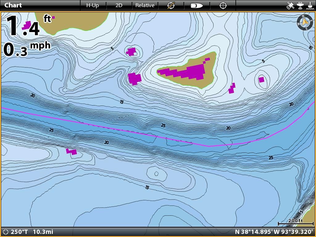
Doug would you happen to have the great lakes version 2 card? If so could you post a couple screen shots of Geist Reservoir? I really want to get the lakemaster card cause I like a lot of the features but im not sure how much detail my lake shows. I have a hummingbird 798 with the countour xd maps which I don't think shows much detail at all.
Where is Geist Reservoir so I can find it easier. I'll try to get some images this weekend for you.
--
http://www.dougvahrenberg.com/
BASS Central Open- Competitive Bass Angler and Humminbird Guru
Visit my website to learn about my sponsor's products, fishing tips and techniques.
Learn More About Humminbird Side Imaging Visit: http://groups.yahoo.com/group/sideimaginggroup/
Ok thanks. It is in fishers, Indiana. The north east side of Indianapolis.
I added the images to the Great Lakes Region Album here: http://www.bbcboards.net/humminbird-...ml#post3066794
Hope it helps.
--
http://www.dougvahrenberg.com/
BASS Central Open- Competitive Bass Angler and Humminbird Guru
Visit my website to learn about my sponsor's products, fishing tips and techniques.
Learn More About Humminbird Side Imaging Visit: http://groups.yahoo.com/group/sideimaginggroup/
Yep I found it. Thanks again.
I hope this is the place to post this question. I bought a Mid south states card today v.2, I fish Lake fork mostly and it doesn't show that awesome detail on my HB 798 ci SI. Is that probably because I need to update the software to the latest version?
Mapping data should be the same not matter the unit. Can you post an example of what you are seeing? What details are missing?
--
http://www.dougvahrenberg.com/
BASS Central Open- Competitive Bass Angler and Humminbird Guru
Visit my website to learn about my sponsor's products, fishing tips and techniques.
Learn More About Humminbird Side Imaging Visit: http://groups.yahoo.com/group/sideimaginggroup/
the different colored highlights ability to where I can make the shoreline red, or highlight certain depths a different color. Like on the pics you posted on page 1 of this thread, it just looks like normal contour lines. Just black and white with the water shaded blue.
And it says loading charts, but none of the options are there when it loads
I'm on version 4.310 if that matters
Last edited by BigJfrank; 06-30-2014 at 09:20 AM.


 Reply With Quote


