Results 1 to 18 of 18
  1. #1
    Member
    Join Date
    Jan 2005
    Location
    Dripping Springs
    Posts
    133

    Question Navionics and Lake Master Chart Questions's for Humminbird Solix

    I'm about to update the electronics on my boat as my Lowrance units are now 8 years old. I am very open to switching to Humminbird. To help me make my decision, I have a few questions about chart options for Humminbird Solix units.

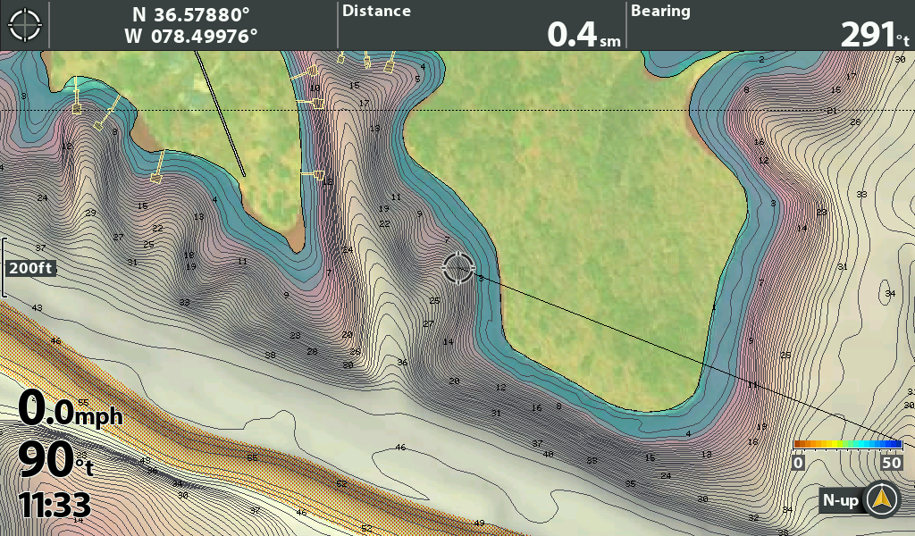
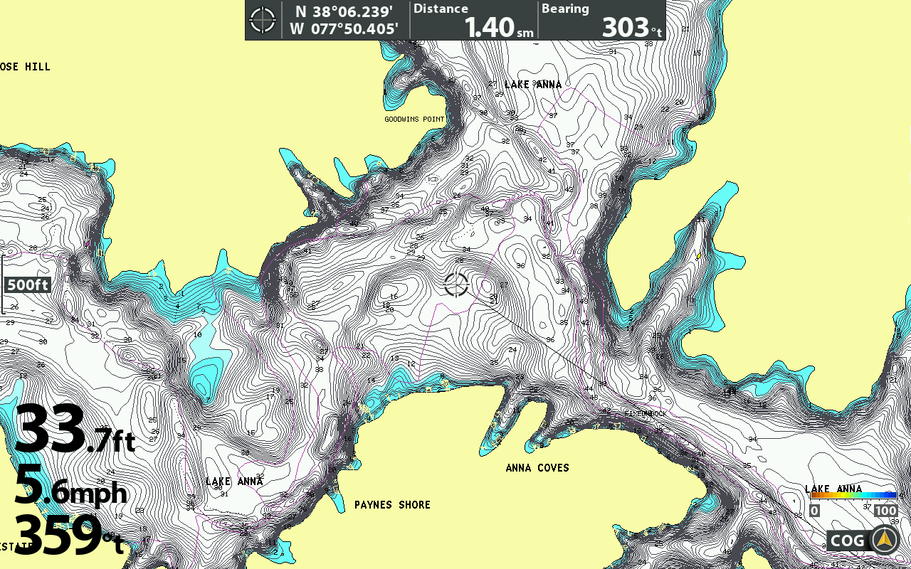
    I really like the LakeMaster chart quality for the lakes they support with HD. I also really like the depth highlight and water offset features. Unfortunately, the number of lakes covered in Texas is pretty poor compared to CMAP Contour+ and Navionics. Is there any information as to when Humminbird is going to update their LakeMaster charts and what lakes will be added? If LakeMaster lake coverage matched CMAP Contour+ lake coverage it would be hard to beat LakeMaster charting. As it stands with today list of lakes, they literally cover less than half the lakes I regularly fish while CMAP Contour+ and Navionics support all the lakes I regularly fish.

    Is there any ability to do the depth highlight and lake level offset with Navionics charting on Humminbird Solix units? I believe the answer is no. If I'm wrong, then a combination of Navionics and LakeMaster charts might be the ticket if I go with Humminbird.

    Marlin Frederick

  2. Member
    Join Date
    Apr 2008
    Location
    Lakeview,AR.
    Posts
    8,050
    #2
    No, the features are built in the map. The numbers on the contour lines need to be manipulated to do offset. The newer Navionics have some color options that can be manipulated by the latest HB updates and the new units. G4 Helix and G3 Solix. There are a mess of HD lakes listed in Texas but the ones that count are the ones you fish. Bob
    Tell me where has a slow movin' once quick draw outlaw got to go

  3. Member Wayne P.'s Avatar
    Join Date
    Jan 2010
    Location
    Charlottesville, VA
    Posts
    30,398
    #3
    Humminbirds read Navionics and Lakemaster digital mapping.

    Lakemaster has new issues annually==about March is when they start being released.
    Never has been any information ahead of time as to what will be added, you can view the new lists as they are released on the Humminbird website.
    Lakemaster started in the upper mid-west, then Johnson Outdoors bought the company and its coverage has expanded. It has not been in operation as long as Navionics.

    Sometimes if a particular HD survey is done mid-year and is ready for publishing, it is added to the Chart Select list for individual purchase. You can check that list as those places will be in the 2021 regional releases.

    No there are no adjustments like that for Navionics, those are adjustments for Lakemaster mapping in Humminbird units.
    Johnson Outdoors owns Humminbird and Lakemaster, their stuff works with their stuff.
    Wayne Purdum
    Charlottesville, Va.
    Helix 12 CHIRP MEGA+ SI G3N/G4N, Helix 15 CHIRP MEGA SI+ GPS G4N
    SOLIX 12 SI/G3, Helix 8 CHIRP MEGA SI+ G4N, Ultrex 80/LINK, MEGA360,
    MEGA LIVE, LIVE TL

  4. Member
    Join Date
    Apr 2008
    Location
    Lakeview,AR.
    Posts
    8,050
    #4
    I saw the update on Auto routing and Fix on user interface for Navionics. Thought it was about the the depth color features. Guess not. Bob
    Went to the site HB not listed for those features.
    Tell me where has a slow movin' once quick draw outlaw got to go

  5. Member Wayne P.'s Avatar
    Join Date
    Jan 2010
    Location
    Charlottesville, VA
    Posts
    30,398
    #5
    Quote Originally Posted by bobcoy View Post
    I saw the update on Auto routing and Fix on user interface for Navionics. Thought it was about the the depth color features. Guess not. Bob
    There is a colored contour feature added with an updated Navionics Hotmaps Platinum card, but I have not seen any adjustability for it. I updated one of my cards to check it out.

    Wayne Purdum
    Charlottesville, Va.
    Helix 12 CHIRP MEGA+ SI G3N/G4N, Helix 15 CHIRP MEGA SI+ GPS G4N
    SOLIX 12 SI/G3, Helix 8 CHIRP MEGA SI+ G4N, Ultrex 80/LINK, MEGA360,
    MEGA LIVE, LIVE TL

  6. Member
    Join Date
    Jan 2005
    Location
    Dripping Springs
    Posts
    133
    #6
    Thanks for the clear answers everyone. My research lead me to pretty much the same conclusions, but I wanted to be sure. Technology changes rapidly in this space, so it is easy to get something wrong due to dated info. I did check the Chart Select website but I didn't see any new lakes of interest to me. My area is pretty sparsely covered in general.

    It seems I might want to wait until March to pull the trigger on my update, but I really would like to have everything in place for the great fishing that usually starts around February. Decisions, decisions ...

    Marlin Frederick

  7. Member
    Join Date
    Aug 2020
    Location
    Baton Rouge, Louisiana
    Posts
    903
    #7
    I ordered a platinum plus card in December, they were running a $100 rebate on the card I bought. I can't wait to have something to use it in.

  8. Member
    Join Date
    Dec 2020
    Location
    Boise, ID
    Posts
    80
    #8
    I'm in a similar situation to Marlin regarding updating my electronics, all original to the used 2015 boat I bought which is why I'm upgrading before the season with Solix being my frontrunner. Lakemaster in Idaho doesn't have most of the lakes I fish mapped in HD, so I'm thinking Navionics is a better option.

    Regarding lake level offset, the lakes I fish are reservoirs and the lake level fluctuates quite a bit. How can this be addressed with Solix & Navionics?

    Also with Navionics, their lake list doesn't specify if a lake is mapped in HD or not. Anybody know how to find this out?

    Forgive some of the newbie questions here. Thanks.

    Blair

  9. Member Wayne P.'s Avatar
    Join Date
    Jan 2010
    Location
    Charlottesville, VA
    Posts
    30,398
    #9
    Quote Originally Posted by DogWalker View Post
    I'm in a similar situation to Marlin regarding updating my electronics, all original to the used 2015 boat I bought which is why I'm upgrading before the season with Solix being my frontrunner. Lakemaster in Idaho doesn't have most of the lakes I fish mapped in HD, so I'm thinking Navionics is a better option.

    Regarding lake level offset, the lakes I fish are reservoirs and the lake level fluctuates quite a bit. How can this be addressed with Solix & Navionics?

    Also with Navionics, their lake list doesn't specify if a lake is mapped in HD or not. Anybody know how to find this out?

    Forgive some of the newbie questions here. Thanks.

    Blair
    The ONLY adjustment you would have is to use the depth highlighting set to the water level and don't try to run in the blue highlighted areas. Blue would be land.

    Wayne Purdum
    Charlottesville, Va.
    Helix 12 CHIRP MEGA+ SI G3N/G4N, Helix 15 CHIRP MEGA SI+ GPS G4N
    SOLIX 12 SI/G3, Helix 8 CHIRP MEGA SI+ G4N, Ultrex 80/LINK, MEGA360,
    MEGA LIVE, LIVE TL

  10. Member Wayne P.'s Avatar
    Join Date
    Jan 2010
    Location
    Charlottesville, VA
    Posts
    30,398
    #10
    Quote Originally Posted by DogWalker View Post
    I'm in a similar situation to Marlin regarding updating my electronics, all original to the used 2015 boat I bought which is why I'm upgrading before the season with Solix being my frontrunner. Lakemaster in Idaho doesn't have most of the lakes I fish mapped in HD, so I'm thinking Navionics is a better option.

    Regarding lake level offset, the lakes I fish are reservoirs and the lake level fluctuates quite a bit. How can this be addressed with Solix & Navionics?

    Also with Navionics, their lake list doesn't specify if a lake is mapped in HD or not. Anybody know how to find this out?

    Forgive some of the newbie questions here. Thanks.

    Blair
    Current Navionics maps can be viewed on the Navionics website's Chart Viewer. They are updated daily. If you purchase a map card today and update it today, you will have today's maps.

    There are two map layers:
    Nautical Charts is Navionics maps.
    Sonar Charts is HD mapping created from unit owner sonar logs.
    There is a round icon at the lower left of the panel, click on it to change between the map types.
    The curved lines icon is Sonar Charts and the zigzag icon is Nautical Charts.
    Wayne Purdum
    Charlottesville, Va.
    Helix 12 CHIRP MEGA+ SI G3N/G4N, Helix 15 CHIRP MEGA SI+ GPS G4N
    SOLIX 12 SI/G3, Helix 8 CHIRP MEGA SI+ G4N, Ultrex 80/LINK, MEGA360,
    MEGA LIVE, LIVE TL

  11. Dink Flipper alpine4x4's Avatar
    Join Date
    May 2011
    Location
    East Wenatchee, WA
    Posts
    4,542
    #11
    Quote Originally Posted by DogWalker View Post
    I'm in a similar situation to Marlin regarding updating my electronics, all original to the used 2015 boat I bought which is why I'm upgrading before the season with Solix being my frontrunner. Lakemaster in Idaho doesn't have most of the lakes I fish mapped in HD, so I'm thinking Navionics is a better option.

    Regarding lake level offset, the lakes I fish are reservoirs and the lake level fluctuates quite a bit. How can this be addressed with Solix & Navionics?

    Also with Navionics, their lake list doesn't specify if a lake is mapped in HD or not. Anybody know how to find this out?

    Forgive some of the newbie questions here. Thanks.

    Blair
    Navionics really doesnt do much for us up here in the PNW. CDA will be well mapped and even has some of the contour highlight features, but beyond that they use old topographic data thats not accurate at all. Lakemaster has a few more lakes, at least for us in WA.

    Like Wayne showed the only way to do an offset with Navionics is to do low water highlight. I use that on Potholes in the fall. Its not ideal, but it works.
    06 Skeeter 20i Yamaha 250 HPDI
    Visit my Youtube Channel!
    https://www.youtube.com/channel/UCW6p06navSpOqUn3xotG2vA

  12. Humminbird Moderator SLYDoggie's Avatar
    Join Date
    Aug 2015
    Location
    Franklin TN & Tims Ford Lake
    Posts
    3,897
    #12
    Quote Originally Posted by DogWalker View Post
    I'm in a similar situation to Marlin regarding updating my electronics, all original to the used 2015 boat I bought which is why I'm upgrading before the season with Solix being my frontrunner. Lakemaster in Idaho doesn't have most of the lakes I fish mapped in HD, so I'm thinking Navionics is a better option.

    Regarding lake level offset, the lakes I fish are reservoirs and the lake level fluctuates quite a bit. How can this be addressed with Solix & Navionics?

    Also with Navionics, their lake list doesn't specify if a lake is mapped in HD or not. Anybody know how to find this out?

    Forgive some of the newbie questions here. Thanks.

    Blair
    I have a Navionics Map but rarely use it. I like the 3D view capability as well as the fact that it shows the docks on my lake but not having Lake Level Offset is a show stopper for me. My home lake fluctuates up to 20' with a winter pool at 15' below summer pool and spring rains driving the lake up to 5' over summer pool. For me, that makes the Navionics all but useless except when the lake is at summer pool.

    Unfortunately Lakemaster doesn't have a HD map of the lake but, fortunately, the updated basemap for the Solix is pretty decent. In my case I decided to map my 10,000 acre lake myself with Autochart Live. You have the ability to do lake level offset with Autochart Live and, since I mapped it myself, I know it's accurate. Over the last few years I have mapped about 90% of the lake but would still buy a Lakemaster HD map if one became available.
    ---> Regards, Steve Yarbrough (AKA: SLYDoggieTN on YouTube)
    • Apex 19/16/13, Mega 360, and Mega Live
    • Minn Kota Ulterra Quest Trolling Motor
    • (2) Cannon Optimum Bluetooth Downriggers
    • Impulse Lithium Batteries... 36V 60AH for Trolling Motor, (2) 12V 120AH for Cranking & Electronics, 12V 60AH for Downriggers


  13. Member
    Join Date
    Dec 2020
    Location
    Boise, ID
    Posts
    80
    #13
    Quote Originally Posted by SLYDoggie View Post
    I have a Navionics Map but rarely use it. I like the 3D view capability as well as the fact that it shows the docks on my lake but not having Lake Level Offset is a show stopper for me. My home lake fluctuates up to 20' with a winter pool at 15' below summer pool and spring rains driving the lake up to 5' over summer pool. For me, that makes the Navionics all but useless except when the lake is at summer pool.

    Unfortunately Lakemaster doesn't have a HD map of the lake but, fortunately, the updated basemap for the Solix is pretty decent. In my case I decided to map my 10,000 acre lake myself with Autochart Live. You have the ability to do lake level offset with Autochart Live and, since I mapped it myself, I know it's accurate. Over the last few years I have mapped about 90% of the lake but would still buy a Lakemaster HD map if one became available.
    That’s a really good point about Autochart Live, Steve. Doing some reading on the forums, lake offset and future integration with iPilot Link is having me lean towards Lakemaster. From what I’m reading, there’s not a lot of people who think Lakemaster Plus is all that great.

    Regarding Autochart Live, does that require a lot of storage? I’d probably need to chart 3-4 lakes that aren’t on the Lakemaster HD list.

    Thanks,
    Blair

  14. Member Wayne P.'s Avatar
    Join Date
    Jan 2010
    Location
    Charlottesville, VA
    Posts
    30,398
    #14
    Quote Originally Posted by DogWalker View Post
    That’s a really good point about Autochart Live, Steve. Doing some reading on the forums, lake offset and future integration with iPilot Link is having me lean towards Lakemaster. From what I’m reading, there’s not a lot of people who think Lakemaster Plus is all that great.

    Regarding Autochart Live, does that require a lot of storage? I’d probably need to chart 3-4 lakes that aren’t on the Lakemaster HD list.

    Thanks,
    Blair
    Built-in Auto Chart Live has a capacity of 8 recording hours.
    Once that is full, you can delete it or transfer the data to a Zero Line card.
    You can also record directly to the Zero Line card and have enough memory for the rest of your life.

    The Zero Line card has millions of Zero Lines (shorelines).
    Auto Chart Live is overlayed on whatever map background you use.

    If you convert it to Auto Chart with the computer software Auto Chart or Auto Chart Pro, the mapping will be read from the card like the unit does Lakemaster mapping.
    Wayne Purdum
    Charlottesville, Va.
    Helix 12 CHIRP MEGA+ SI G3N/G4N, Helix 15 CHIRP MEGA SI+ GPS G4N
    SOLIX 12 SI/G3, Helix 8 CHIRP MEGA SI+ G4N, Ultrex 80/LINK, MEGA360,
    MEGA LIVE, LIVE TL

  15. Member Wayne P.'s Avatar
    Join Date
    Jan 2010
    Location
    Charlottesville, VA
    Posts
    30,398
    #15
    There is an extensive Auto Chart sticky topic with 1,122 posts so far.
    Wayne Purdum
    Charlottesville, Va.
    Helix 12 CHIRP MEGA+ SI G3N/G4N, Helix 15 CHIRP MEGA SI+ GPS G4N
    SOLIX 12 SI/G3, Helix 8 CHIRP MEGA SI+ G4N, Ultrex 80/LINK, MEGA360,
    MEGA LIVE, LIVE TL

  16. Humminbird Moderator SLYDoggie's Avatar
    Join Date
    Aug 2015
    Location
    Franklin TN & Tims Ford Lake
    Posts
    3,897
    #16
    Quote Originally Posted by Wayne P. View Post
    Built-in Auto Chart Live has a capacity of 8 recording hours.
    Once that is full, you can delete it or transfer the data to a Zero Line card.
    You can also record directly to the Zero Line card and have enough memory for the rest of your life.

    The Zero Line card has millions of Zero Lines (shorelines).
    Auto Chart Live is overlayed on whatever map background you use.

    If you convert it to Auto Chart with the computer software Auto Chart or Auto Chart Pro, the mapping will be read from the card like the unit does Lakemaster mapping.
    Wayne, as you know, I've pretty much mapped all of Tims Ford Lake. You mentioned something in your post that I want to get clarified. I don't have the AutoChart PC software program as I haven't really seen a need. In your post you indicated that you could convert your AutoChart maps. Does that mean that your maps would no longer do the "repainting" process as you troll? That's one thing I don't like about the custom charts on the ZeroLines card is that it is constantly repainting. Sometimes you come into an area and the chart doesn't repaint soon enough. If you convert it with the software does it create the whole lake so you can zoom in and out and still see all of your custom charts?

    If that's the case, then I need to really consider getting the PC software.
    ---> Regards, Steve Yarbrough (AKA: SLYDoggieTN on YouTube)
    • Apex 19/16/13, Mega 360, and Mega Live
    • Minn Kota Ulterra Quest Trolling Motor
    • (2) Cannon Optimum Bluetooth Downriggers
    • Impulse Lithium Batteries... 36V 60AH for Trolling Motor, (2) 12V 120AH for Cranking & Electronics, 12V 60AH for Downriggers


  17. Member Wayne P.'s Avatar
    Join Date
    Jan 2010
    Location
    Charlottesville, VA
    Posts
    30,398
    #17
    Quote Originally Posted by SLYDoggie View Post
    Wayne, as you know, I've pretty much mapped all of Tims Ford Lake. You mentioned something in your post that I want to get clarified. I don't have the AutoChart PC software program as I haven't really seen a need. In your post you indicated that you could convert your AutoChart maps. Does that mean that your maps would no longer do the "repainting" process as you troll? That's one thing I don't like about the custom charts on the ZeroLines card is that it is constantly repainting. Sometimes you come into an area and the chart doesn't repaint soon enough. If you convert it with the software does it create the whole lake so you can zoom in and out and still see all of your custom charts?

    If that's the case, then I need to really consider getting the PC software.
    Auto Chart Live is a DIFFERENT file type than Auto Chart.
    Auto Chart LIVE is what the unit does when creating contour mapping in the unit's memory or to a Zero Line Card.
    That is what you can watch being created in real time.
    As stated above, it is ONLY an overlay on the Chart view.

    Auto Chart
    is created via the computer software Auto Chart or Auto Chart Pro. You can convert Auto Chart LIVE data to Auto Chart with those softwares. You can also do RECORD to a blank memory card and use that data with the two computer softwares to create Auto Chart maps. Once the computer software creates the Auto Chart contour mapping, you have to copy it to a Zero Line card to use it in a unit. It is read just like a Lakemaster map card.

    If you have a Zero Line Card in the unit viewing Auto Chart mapping, if you do Auto Chart LIVE, it will be an overlay on the Auto Chart map and not part of it==same as if you would use Lakemaster, Navionics, built-in basemap to overlay LIVE on.
    Think TWO DIFFERENT FILE TYPES unrelated to each other.

    And before you ask, no I do not know if you can view Auto Chart and record Auto Chart Live on the same Zero Line card at the same time. I don't have either computer software to create Auto Chart maps.
    Wayne Purdum
    Charlottesville, Va.
    Helix 12 CHIRP MEGA+ SI G3N/G4N, Helix 15 CHIRP MEGA SI+ GPS G4N
    SOLIX 12 SI/G3, Helix 8 CHIRP MEGA SI+ G4N, Ultrex 80/LINK, MEGA360,
    MEGA LIVE, LIVE TL

  18. Member
    Join Date
    Dec 2020
    Location
    Boise, ID
    Posts
    80
    #18
    Thanks for all the great info gents, much appreciated.

    Blair