Results 1 to 18 of 18
  1. #1
    Member
    Join Date
    Aug 2016
    Location
    Grand Prairie TX
    Posts
    162

    Navionics HotMaps Platinum relief shading overlays

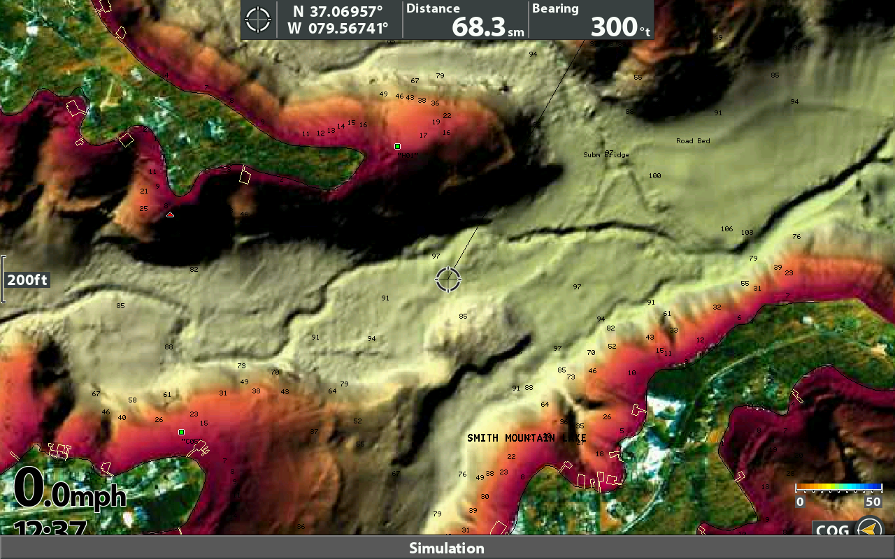
    Just purchased a new Navionics HotMaps Platinum with relief shading to use with my Helix 12 Gen3 SI. I pretty much only use this unit for mapping. I do have a Helix 12 DI Gen3 on the bow which I may swap (move SI to Bow and DI to console).

    My full set up right now is 2 Helix 12 SI Gen3 units on console and 1 Helix 12 DI Gen3 and Garmin Echomap Ultra 102 on bow.

    My question is how do I or can I get relief shading to show on my my unit?

    Any help or suggestions would be appreciated

    Thanks

  2. Member Wayne P.'s Avatar
    Join Date
    Jan 2010
    Location
    Charlottesville, VA
    Posts
    30,437
    #2
    A new purchase has to be registered and updated to start the Freshest Data Update subscription that lasts a year. AND is renewable annually.
    It doesn't have Relief Shading until you do an update to add it.
    Did you read the instructions?

    How to Get Relief Shading
    GPS Plotter
    Included as a downloadable option with Platinum cards, it can be viewed with compatible models from many brands.


    Wayne Purdum
    Charlottesville, Va.
    Helix 12 CHIRP MEGA+ SI G3N/G4N, Helix 15 CHIRP MEGA SI+ GPS G4N
    SOLIX 12 SI/G3, Helix 8 CHIRP MEGA SI+ G4N, Ultrex 80/LINK, MEGA360,
    MEGA LIVE, LIVE TL

  3. Member
    Join Date
    Aug 2016
    Location
    Grand Prairie TX
    Posts
    162
    #3
    Yes Sir, first thing I did was update the card and add the relief shading, after I couldn't get it to work the first time i download it again with just my lake highlighted. Read instructions (attached) that I found on the web and still cannot get it to pull up. maybe I am missing something
    Attached Files Attached Files

  4. Member Wayne P.'s Avatar
    Join Date
    Jan 2010
    Location
    Charlottesville, VA
    Posts
    30,437
    #4
    Quote Originally Posted by DMV631 View Post
    Yes Sir, first thing I did was update the card and add the relief shading, after I couldn't get it to work the first time i download it again with just my lake highlighted. Read instructions (attached) that I found on the web and still cannot get it to pull up. maybe I am missing something
    Those instructions are sort of outdated.

    Relief Shading is not even shown in the Compatibility chart.

    Several recent Navionics features are usable with Lowrance units and not with Humminbird units. That may be the case with Relief Shading.
    You can add Community Edits to your map card, but you cannot see them with a Helix or number series units.

    Just going by what that feature looks like, it would take the Bird's Eye 3D view to display it. So I would guess if a Humminbird is compatible, that would be the path to take.
    Wayne Purdum
    Charlottesville, Va.
    Helix 12 CHIRP MEGA+ SI G3N/G4N, Helix 15 CHIRP MEGA SI+ GPS G4N
    SOLIX 12 SI/G3, Helix 8 CHIRP MEGA SI+ G4N, Ultrex 80/LINK, MEGA360,
    MEGA LIVE, LIVE TL

  5. Member
    Join Date
    Aug 2016
    Location
    Grand Prairie TX
    Posts
    162
    #5
    Was thinking the same thing that it will probably work with lowrance but maybe not Humminbirds, will try your suggestion on the birds eye view when i get back to the boat.

    Thanks for your input!!

  6. Member
    Join Date
    Aug 2016
    Location
    Grand Prairie TX
    Posts
    162
    #6

    Post

    Forgot to update after I got this working.

    Hit menu twice, go to the Platinum menu and in chart aerial overlay you have the options for
    • Hidden - original contours
    • Land - original contours with Satellite land overlay
    • Land + Water - Satellite land and relief shading


    Set Platinum 3D to visible and 3d Aerial overlay to visible
    Note that for the relief shading to show up you will have to zoom out quite a bit for it to work otherwise it will show the contour lines but the background (lake) will just have a green tint to it.
    Attached Images Attached Images

  7. Member
    Join Date
    Oct 2022
    Location
    Maryland
    Posts
    16
    #7
    HEY DMV, this is an image of what the "relief Shading " shows up as on your Helix?Screen Shot 2022-10-13 at 7.21.38 AM.jpg

  8. Member Wayne P.'s Avatar
    Join Date
    Jan 2010
    Location
    Charlottesville, VA
    Posts
    30,437
    #8
    Quote Originally Posted by WaltF View Post
    HEY DMV, this is an image of what the "relief Shading " shows up as on your Helix?Screen Shot 2022-10-13 at 7.21.38 AM.jpg

    Wayne Purdum
    Charlottesville, Va.
    Helix 12 CHIRP MEGA+ SI G3N/G4N, Helix 15 CHIRP MEGA SI+ GPS G4N
    SOLIX 12 SI/G3, Helix 8 CHIRP MEGA SI+ G4N, Ultrex 80/LINK, MEGA360,
    MEGA LIVE, LIVE TL

  9. Member
    Join Date
    Oct 2022
    Location
    Maryland
    Posts
    16
    #9
    Thanks Wayne, I tried the steps listed by DMV to no avail....I cannot get anything close to what your showing there

    I have a Helix 10 MSI G4...Ulterra Pilot Link....a platinum plus Navionics with relief shading downloaded and cannot figure out how to get it to display....

  10. Member
    Join Date
    Oct 2022
    Location
    Maryland
    Posts
    16
    #10
    you think this might have something to do with it?Screen Shot 2022-10-13 at 9.30.53 AM Medium.jpeg

  11. Member Wayne P.'s Avatar
    Join Date
    Jan 2010
    Location
    Charlottesville, VA
    Posts
    30,437
    #11
    Quote Originally Posted by WaltF View Post
    Thanks Wayne, I tried the steps listed by DMV to no avail....I cannot get anything close to what your showing there

    I have a Helix 10 MSI G4...Ulterra Pilot Link....a platinum plus Navionics with relief shading downloaded and cannot figure out how to get it to display....
    The location of that image is Smith Mountain Lake and I did that with the unit on my desk.

    Not all waters have that feature and it takes a location that has a lot of depth to get that much relief shading.
    Wayne Purdum
    Charlottesville, Va.
    Helix 12 CHIRP MEGA+ SI G3N/G4N, Helix 15 CHIRP MEGA SI+ GPS G4N
    SOLIX 12 SI/G3, Helix 8 CHIRP MEGA SI+ G4N, Ultrex 80/LINK, MEGA360,
    MEGA LIVE, LIVE TL

  12. Member
    Join Date
    Oct 2022
    Location
    Maryland
    Posts
    16
    #12
    Trying John Kerr Reservoir which is listed as having "relief shading"

  13. Member
    Join Date
    Jan 2018
    Location
    little rock, ar
    Posts
    311
    #13
    Quote Originally Posted by DMV631 View Post
    Forgot to update after I got this working.

    Hit menu twice, go to the Platinum menu and in chart aerial overlay you have the options for
    • Hidden - original contours
    • Land - original contours with Satellite land overlay
    • Land + Water - Satellite land and relief shading


    Set Platinum 3D to visible and 3d Aerial overlay to visible
    Note that for the relief shading to show up you will have to zoom out quite a bit for it to work otherwise it will show the contour lines but the background (lake) will just have a green tint to it.
    you have to do what you have listed, but then go over to I think it is the "chart" tab and deselect "sonar returns ?" and then you can see relief shading. I don't have my unit in front of me for the exact name of the option under the chart tab. this assumes your platinum card was recently updated and the reels shading option was checked during the update and your lake was in the area chosen within the blue dots when you did the card update on your computer.

    hope this makes sense ?

    thesis what relief shading should look like on joe pool lake
    Attached Images Attached Images
    Last edited by suvowner; 10-13-2022 at 10:34 AM.
    2016 Tracker pro team 175txw 75hp 4 stroke
    helix 12 si console helix 10 di and helix 10 si bow and ulterra 80 i-pilot link and transom 360 and Garmin 126sv and Livescope

  14. Member
    Join Date
    Jan 2018
    Location
    little rock, ar
    Posts
    311
    #14
    Quote Originally Posted by WaltF View Post
    Trying John Kerr Reservoir which is listed as having "relief shading"
    john kerr with relief shading. you have to subscribe to the app on a mobile device to see the lakes with relief shading.

    Screenshot 2022-10-13 at 10.40.47 AM.jpg
    2016 Tracker pro team 175txw 75hp 4 stroke
    helix 12 si console helix 10 di and helix 10 si bow and ulterra 80 i-pilot link and transom 360 and Garmin 126sv and Livescope

  15. Member Wayne P.'s Avatar
    Join Date
    Jan 2010
    Location
    Charlottesville, VA
    Posts
    30,437
    #15
    If you have Sonar Charts turned on, you have to turn that off to display the Navionics map.
    Wayne Purdum
    Charlottesville, Va.
    Helix 12 CHIRP MEGA+ SI G3N/G4N, Helix 15 CHIRP MEGA SI+ GPS G4N
    SOLIX 12 SI/G3, Helix 8 CHIRP MEGA SI+ G4N, Ultrex 80/LINK, MEGA360,
    MEGA LIVE, LIVE TL

  16. Member
    Join Date
    Apr 2008
    Location
    Lakeview,AR.
    Posts
    8,068
    #16
    Just noticed a manual that has the VX stuff in it. https://johnsonoutdoors.widen.net/co...ser-Manual.pdf
    Sorry I posted on the wrong post
    Tell me where has a slow movin' once quick draw outlaw got to go

  17. Member
    Join Date
    Oct 2022
    Location
    Maryland
    Posts
    16
    #17
    got it had to set overlay transparency to "O"...no actual option marked "relief overlay"..also had to turn off Sonar Charts...thanks for the steering Wayne
    Last edited by WaltF; 10-13-2022 at 05:33 PM.

  18. Member
    Join Date
    Sep 2016
    Location
    Ellis County Texas
    Posts
    5
    #18
    Having a similar issue with relief shading, each lake i go to i get about half the lake with satellite imagery and relief shading and the other half is the standard navionics contour. I have deleted the card and redownloaded the area and still the same issue. Zoomin in or out doesnt help.