Results 1 to 10 of 10
  1. #1
    Member
    Join Date
    Jun 2004
    Location
    Calvert City, Kentucky
    Posts
    787

    Worth updating Navionics Platinum card subscription? East

    So I have upgraded my units, bought the new Cmap for my area, but my old Navionics Plat card has expired. for 99$ I can update? not interested in sat imagery, Is it worth it> ?better topo features? Used mainly on KY lake , Dale hollow , Guntersville, Chickamauga

    appreciate your thoughts

  2. Member
    Join Date
    Jun 2015
    Location
    Dayton, MN
    Posts
    111
    #2
    Quote Originally Posted by Lykins Tr21 View Post
    So I have upgraded my units, bought the new Cmap for my area, but my old Navionics Plat card has expired. for 99$ I can update? not interested in sat imagery, Is it worth it> ?better topo features? Used mainly on KY lake , Dale hollow , Guntersville, Chickamauga

    appreciate your thoughts
    It depends. In the last few years Navionics offers the update in the form of a new chip, and of course the 1 year update functionality as well as Sonar Charts Live (Depending on your Lowrance unit, you make have Genesis Live as well). I always have guys willing to buy my old chip as it still works but no updates. A new platinum chip is $199. I have sold my year old chips for $50, leaving my annual upgrade at $50. Before Garmin bought Navionics the price was $75 with a new chip, pretty good deal upgrading with a new chip for $25. Updates include a lot of things however specifically to your lakes, it's hard to tell. It is my understanding that Navionics shares community updates and existing sonar chart live information but no waypoints. I think it's a pretty clever idea to get your users to update the maps yet to be honest I have only noticed a couple of areas where I can see the improvements in the contour lines.

  3. Member Wayne P.'s Avatar
    Join Date
    Jan 2010
    Location
    Charlottesville, VA
    Posts
    30,420
    #3
    Quote Originally Posted by DavidAnderson View Post
    It depends. In the last few years Navionics offers the update in the form of a new chip, and of course the 1 year update functionality as well as Sonar Charts Live (Depending on your Lowrance unit, you make have Genesis Live as well). I always have guys willing to buy my old chip as it still works but no updates. A new platinum chip is $199. I have sold my year old chips for $50, leaving my annual upgrade at $50. Before Garmin bought Navionics the price was $75 with a new chip, pretty good deal upgrading with a new chip for $25. Updates include a lot of things however specifically to your lakes, it's hard to tell. It is my understanding that Navionics shares community updates and existing sonar chart live information but no waypoints. I think it's a pretty clever idea to get your users to update the maps yet to be honest I have only noticed a couple of areas where I can see the improvements in the contour lines.
    Community Edits is waypoints just in note form on the map card. Regular waypoints are NOT map data and have nothing to do with mapping. Waypoints are overlayed on the Chart view and exist whether or not there is any map background.

    Since you can view the current maps on the Navionics website's Chart Viewer, you can check occasionally if there is any new data you don't have, then renew the Freshest Data subscription to download the current map/s. Navionics does about 2,000 updates for their data ( Nautical Charts) "somewhere" daily plus any unit user sonar log generated HD mapping that is Sonar Charts.
    Wayne Purdum
    Charlottesville, Va.
    Helix 12 CHIRP MEGA+ SI G3N/G4N, Helix 15 CHIRP MEGA SI+ GPS G4N
    SOLIX 12 SI/G3, Helix 8 CHIRP MEGA SI+ G4N, Ultrex 80/LINK, MEGA360,
    MEGA LIVE, LIVE TL

  4. Member
    Join Date
    Jun 2004
    Location
    Calvert City, Kentucky
    Posts
    787
    #4
    Yes I don't know if worth updating on Ky lake

  5. Member Wayne P.'s Avatar
    Join Date
    Jan 2010
    Location
    Charlottesville, VA
    Posts
    30,420
    #5
    Quote Originally Posted by Lykins Tr21 View Post
    Yes I don't know if worth updating on Ky lake
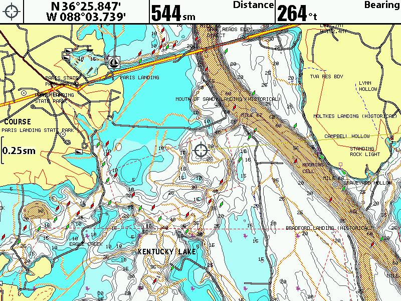
    Kentucky Lake was re-surveyed about 5 years ago, took them a few months to do it. You can tell which ones are new or re-surveys by the way the creek and river channels are highlighted:

    Wayne Purdum
    Charlottesville, Va.
    Helix 12 CHIRP MEGA+ SI G3N/G4N, Helix 15 CHIRP MEGA SI+ GPS G4N
    SOLIX 12 SI/G3, Helix 8 CHIRP MEGA SI+ G4N, Ultrex 80/LINK, MEGA360,
    MEGA LIVE, LIVE TL

  6. Member
    Join Date
    Jun 2004
    Location
    Calvert City, Kentucky
    Posts
    787
    #6
    think my card is only 2 yrs old , so prob don't need to update it? what you think Wayne P??

  7. Member Wayne P.'s Avatar
    Join Date
    Jan 2010
    Location
    Charlottesville, VA
    Posts
    30,420
    #7
    Quote Originally Posted by Lykins Tr21 View Post
    think my card is only 2 yrs old , so prob don't need to update it? what you think Wayne P??
    Not for Kentucky Lake IF you updated the card when you bought it. If it looks like my image, that is the latest.
    When you bought the card has no bearing on what data is on the card.
    All Hotmaps Platinum East Region cards have been E6 since 2010 when the Freshest Data program started.
    You can check the map dates by putting the map card in your computer, open the drive that it is in, and click on the Navionic folder. All the maps will have the date the data was put on the card.
    Wayne Purdum
    Charlottesville, Va.
    Helix 12 CHIRP MEGA+ SI G3N/G4N, Helix 15 CHIRP MEGA SI+ GPS G4N
    SOLIX 12 SI/G3, Helix 8 CHIRP MEGA SI+ G4N, Ultrex 80/LINK, MEGA360,
    MEGA LIVE, LIVE TL

  8. Member
    Join Date
    Jun 2004
    Location
    Calvert City, Kentucky
    Posts
    787
    #8
    Wellmy map looks same as yours at that zoom level at the Paris Bridge.

    the folder shows it was created April 2014, and was last modified june 2017

    But now with the card in my New Live unit , certain options are now longer available like fishing range, think that was the ability to color certain depths, advanced options are inactive (per popup menu) shallow water and safety depth still work...

  9. Member Wayne P.'s Avatar
    Join Date
    Jan 2010
    Location
    Charlottesville, VA
    Posts
    30,420
    #9
    Quote Originally Posted by Lykins Tr21 View Post
    Wellmy map looks same as yours at that zoom level at the Paris Bridge.

    the folder shows it was created April 2014, and was last modified june 2017

    But now with the card in my New Live unit , certain options are now longer available like fishing range, think that was the ability to color certain depths, advanced options are inactive (per popup menu) shallow water and safety depth still work...
    Don't know much about Lowrance stuff, but I think it has been stated to have all the custom settings that the Freshest Data subscription has to be active.
    Wayne Purdum
    Charlottesville, Va.
    Helix 12 CHIRP MEGA+ SI G3N/G4N, Helix 15 CHIRP MEGA SI+ GPS G4N
    SOLIX 12 SI/G3, Helix 8 CHIRP MEGA SI+ G4N, Ultrex 80/LINK, MEGA360,
    MEGA LIVE, LIVE TL

  10. Member
    Join Date
    Jun 2004
    Location
    Calvert City, Kentucky
    Posts
    787
    #10
    thanks Wayne, I may go ahead and redo my subscription, do they just send you a new card? or can you reactivating your old card?