Results 1 to 17 of 17
  1. #1
    Member
    Join Date
    Mar 2008
    Location
    Alexandria, KY
    Posts
    2,358

    How do you manage your waypoints?

    I am in the process of updating my graphs from 999/1199 to Helix GN3's. I've already exported all the waypoints from each graph and now pulled them into my newly downloaded Humminbird PC software. This is really cool to be able to see them all on google earth and separate them into different files by lake, etc.

    I am the point now that I would liek to be more organized in managing all this data. In the past I just kept all my waypoints on the units in the boat. I marked strcuture, cover,fish on the rear graph and marked Fish catches on the front graph. They way the showed up on the map (green highlighted icon for waypoints from the linked unit) made it pretty easy to see what the waypoint was for. However, over time, I just acquired so many waypoints, especially for lakes I fish often.

    I am just wondering what systems or processes you guys have developed over time to manage and maximize all this information.


    Brett Graham
    Louisville, KY
    L\'raisin Anglers

  2. Member
    Join Date
    Jul 2018
    Location
    Lake Worth, Florida
    Posts
    1,796
    #2
    Back years ago I had a Garmin hand held GPS. I had the garmin software and would download it all. Moved everything into lakes. I would delete all the waypoints on GPS and then download only the lake I was going to. I loved that. Then I went to Lowrance. Maybe time to change to Birds.
    1996 Stratos 201 pro xl
    1996 Johnson Faststrike J150GLEDB

  3. Member
    Join Date
    Sep 2018
    Location
    TN
    Posts
    642
    #3
    I would be interested in how others do this as well. I have been doing similar to your method. I had a unit at bow and unit at console they were not networked, I'd mark fish catches at bow and everything else at console. I've always thought there is probably a better way.

    Not to get off topic but another thing I have been doing...i have the zero lines card at bow and console. I start recording when I get the boat in the water and turn the units on. Everywhere the boat has been is mapped at the console. The unit on the bow is only mapping when sonar is on and trolling motor is deployed...im only mapping where I'm fishing this way. It's very easy to tell if I've fished a spot before.

    Like you, I have upgraded my units and now have them networked and looking for a better way.

  4. Member MichAngler's Avatar
    Join Date
    Dec 2005
    Location
    Royal Oak, MI
    Posts
    6,164
    #4
    I use an old version of Garmin MapSource

    I can see each waypoint on an older Garmin Chart

    I can edit, delete, group, and manage them quickly

    Measure distances from point to point create a one days trip by grabbing just the points I want to fish that day

    This software is over a decade old but yet its decades ahead of anything HB has today
    "The handicapped angler"

  5. Member
    Join Date
    Dec 2010
    Location
    Hot Springs Village
    Posts
    4,174
    #5
    I name my waypoints by using part of the lake name. I keep a file in Humminbird PC for each lake. About once a year I download any new WP* waypoints I saved during the year off my graphs to Humminbird PC, rename to match the others and update each lake file and card. Then delete all the waypoints off the graphs, and upload to my one graph at the console as needed.
    2021 Skeeter ZX225
    2021 Yamaha SHO 225 VF225LA

  6. Member
    Join Date
    Apr 2019
    Location
    IL
    Posts
    5
    #6
    My waypoint management workflow is thru AutoChart's waypoint manager. I keep a separate set of waypoints for each lake in individual files. If I am AutoCharting a lake I can import the associated waypoints and plot them on the map with the AC layers. I may add more waypoints based on the mapping analysis. Before I head out to a lake I transfer that lake's waypoints into the head unit in addition to any mapping updates that have been generated by AutoChart. That way I'm current on both mapping and waypoints.

  7. Member
    Join Date
    Jun 2004
    Location
    Bull Shoals, AR
    Posts
    9,936
    #7
    I save my WPs, Routes and versions of Helix updates by lake name on my PC. I only load WPs and Routes one lake at a time on my Helix 10 units. If I take a road trip, I clear my home lakes from my units and add the data for the lake I'm going to fish. I backup all data in folders on an external hard drive and also on CDs.
    Last edited by BrownTrout; 01-27-2020 at 09:28 AM.

  8. Member
    Join Date
    Mar 2018
    Location
    NE FL
    Posts
    356
    #8
    I name my way points starting with the first letters of the lake name and starting with 001. Example Orange Lake, OL 001 then try to find a icon that fits the wp. Normally use the fish icon for catches and the brush pile icon for structure to keep it simple. Using that naming structure the files end up in groups. Plus I can tell by number if it is a old or newer wp. These units hold more way points then I will ever haveso I just leave them all on the machine. As I used to use my units on my offshore boat I had hundreds of those wps on there also and now my bassboat and bay boat wps also. Don
    Don Johnson
    U S Navy ATC Retired
    NE Florida
    Boat Name TRON
    Crestliner VT 18 DX
    Bow
    Helix 12 Chirp Mega DI+ G3N w/Mega 360 mounted of Fishing Specialties 360 Mount
    Helix 10 Chirp Mega SI G2N
    Garmin GPSMAP 1042 XSV w/LiveScope mounted on Fishing Specialties Bowducer Assy
    Mini Kota Ulterra
    Console
    Helix 12 Chirp Mega SI+ G3N
    Garmin GPSMap 922
    Humminbird PiranaMAX for high speed depth readings

  9. Member
    Join Date
    Jul 2011
    Location
    Woodville, Al
    Posts
    421
    #9
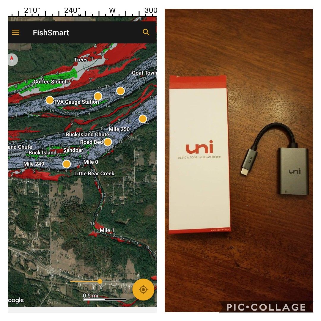
    I use the FishSmart app to manage waypoints for each lake. I can add, edit, delete from anywhere. With an android phone and a USB-to-SD card reader, I can transfer them with easy without the need of a PC. Same with snapshots.
    Solix 12 Gen2 Mega+ SI, Helix 7 DI G3, Helix 10 G3N SI +, Helix 9 G3N SI +.
    Upgraded to Mega imaging from a HDS-12 Carbon

  10. Member
    Join Date
    Mar 2008
    Location
    Alexandria, KY
    Posts
    2,358
    #10
    I have the fish smart App as well and really like it. One thing I don't like (or haven't figured out) is that I can only export 1 waypoiint at a time. I can't select a bunch update. Also would be great to be able to have all the icon options that are available on the Humminbird units.

    Thinking it would be great to have a file for each lake. Export all waypoints from units in boat. 1 icon for console unit (structure,cover, etc). another icon for bow unit (fish catches) and then a third icon for spots marked on the app (new spots that I would want to check out).


    Brett Graham
    Louisville, KY
    L\'raisin Anglers

  11. Member
    Join Date
    Jun 2010
    Location
    Seabrook, TX
    Posts
    1,212
    #11
    Quote Originally Posted by RoughThumbBG View Post
    I have the fish smart App as well and really like it. One thing I don't like (or haven't figured out) is that I can only export 1 waypoiint at a time. I can't select a bunch update. Also would be great to be able to have all the icon options that are available on the Humminbird units.

    Thinking it would be great to have a file for each lake. Export all waypoints from units in boat. 1 icon for console unit (structure,cover, etc). another icon for bow unit (fish catches) and then a third icon for spots marked on the app (new spots that I would want to check out).
    There is a work around for exporting multiple waypoints. You can add multiple waypoints to a route within the FishSmart app then "Export" the route. When you open that file in HumminbirdPC you will have all your waypoints under the "Waypoints" tab and a list of waypoints will also be within the route under the "Routes" tab. You can then delete the route and still have all your waypoints under the "Waypoints" tab. Then save your new file.
    Have a Blessed Day,
    Mike

  12. Member
    Join Date
    Jul 2011
    Location
    Woodville, Al
    Posts
    421
    #12
    Quote Originally Posted by RoughThumbBG View Post
    I have the fish smart App as well and really like it. One thing I don't like (or haven't figured out) is that I can only export 1 waypoiint at a time. I can't select a bunch update. Also would be great to be able to have all the icon options that are available on the Humminbird units.

    Thinking it would be great to have a file for each lake. Export all waypoints from units in boat. 1 icon for console unit (structure,cover, etc). another icon for bow unit (fish catches) and then a third icon for spots marked on the app (new spots that I would want to check out).
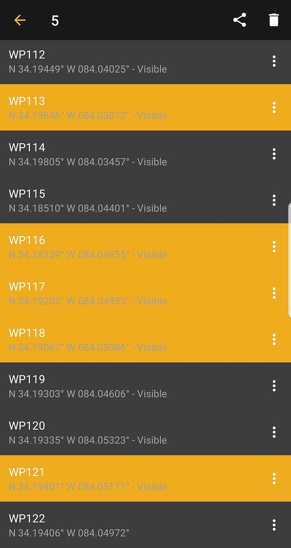
    I just select all the all or some waypoints I want and then export them to a Google drive. Next, I transfer them from the Google drive to the SD card with the phone adapter.

    Solix 12 Gen2 Mega+ SI, Helix 7 DI G3, Helix 10 G3N SI +, Helix 9 G3N SI +.
    Upgraded to Mega imaging from a HDS-12 Carbon

  13. Member
    Join Date
    Jun 2010
    Location
    Seabrook, TX
    Posts
    1,212
    #13
    Quote Originally Posted by jjjaymmman View Post
    I just select all the all or some waypoints I want and then export them to a Google drive. Next, I transfer them from the Google drive to the SD card with the phone adapter.

    How are you selecting multiple waypoints at one time? When I touch a waypoint it automatically takes me to the “Detail” page of that waypoint. I don’t see a way to select several waypoints at one time to export. You mentioned that you use an android device, I wonder if that’s the difference since I’m using an Apple device.
    Have a Blessed Day,
    Mike

  14. Member
    Join Date
    Jul 2011
    Location
    Woodville, Al
    Posts
    421
    #14
    Quote Originally Posted by Mike2718 View Post
    How are you selecting multiple waypoints at one time? When I touch a waypoint it automatically takes me to the “Detail” page of that waypoint. I don’t see a way to select several waypoints at one time to export. You mentioned that you use an android device, I wonder if that’s the difference since I’m using an Apple device.
    I'm using an Android, that may be why.
    Solix 12 Gen2 Mega+ SI, Helix 7 DI G3, Helix 10 G3N SI +, Helix 9 G3N SI +.
    Upgraded to Mega imaging from a HDS-12 Carbon

  15. Member
    Join Date
    Aug 2016
    Location
    Bellevue,NE
    Posts
    57
    #15
    Here’s my system which is similar to D. Johnson’s. Like him I use a few letters of a lake’s name but I have divided the lakes into zones with numbers, then I identify the spot buy a letter. Let say a lake is named Walnut Creek, the way point could be marked WC2a. Another way point might be WC4a. This system allows me to group way points by section of the lake. I have small paper maps of my lakes and have marked them by sections.

  16. Member
    Join Date
    Aug 2004
    Location
    Rockwall, TX
    Posts
    635
    #16
    So you guys that have a file per lake... Guess that is one .gpx file per lake and you can select which one to import? (Sorry brand new to Humminbirds).

  17. Member
    Join Date
    Jun 2013
    Location
    Hemet, CA
    Posts
    4,659
    #17
    Quote Originally Posted by Chris Moore View Post
    So you guys that have a file per lake... Guess that is one .gpx file per lake and you can select which one to import? (Sorry brand new to Humminbirds).
    Correct. If you are fishing a large lake, you can even create a separate file for different areas of the lake. For some reservoirs that I fish, I have different files for different water levels. Depends on quantity of waypoints you want to manage within the limitations of the unit.
    Wes
    Helix 10 MSI+,MDI+,Ultrex IPilot
    2023 Phoenix 818
    Never assume there's a tomorrow